The Rails-to-Trails Conservancy lists wheelchair accessible trails in Montana.
Author: Cecilia
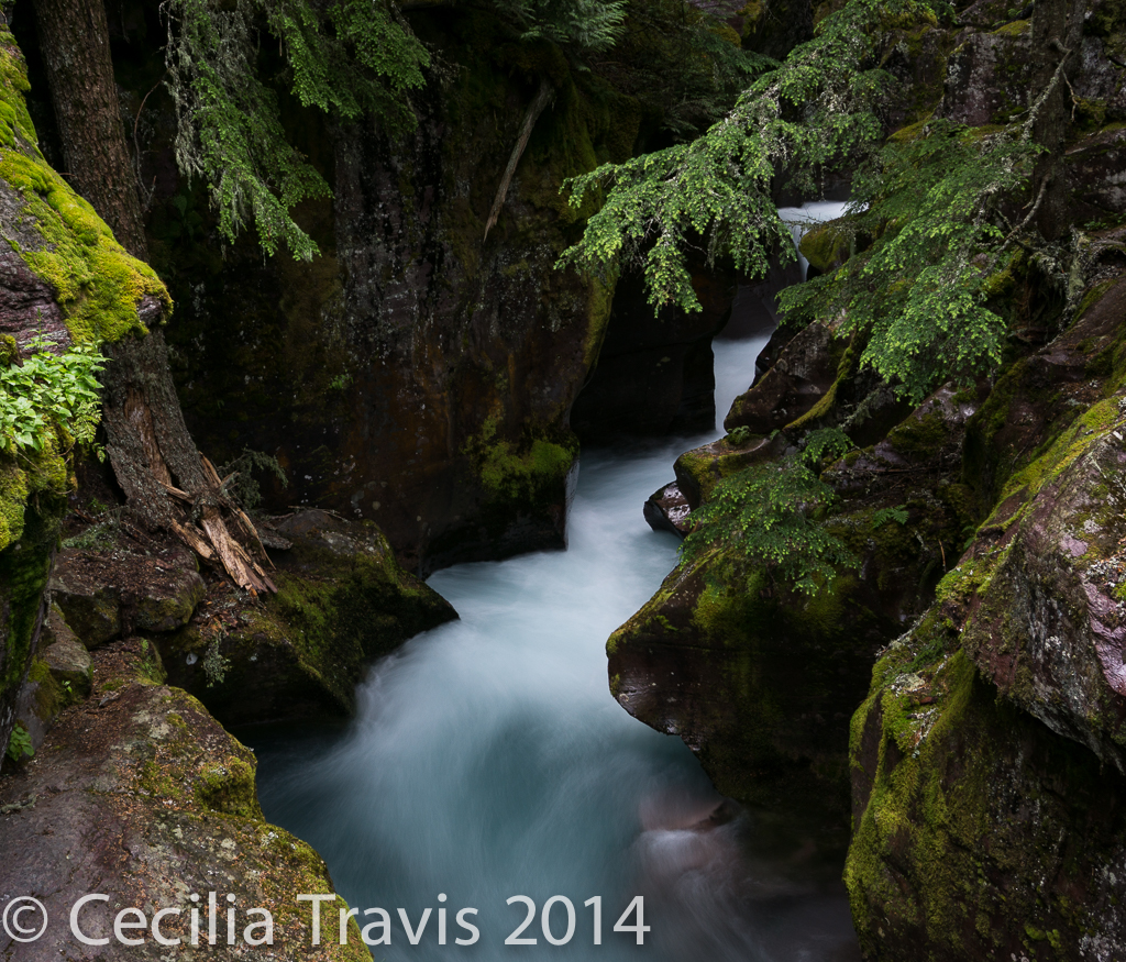
Glacier National Park
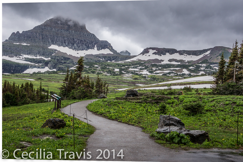
Glacier National Park
Glacier National Park’s 1,583 square miles contain “…pristine forests, alpine meadows, rugged mountains, and spectacular lakes.” The Park habitats encompass several ecotones and exhibit a wide variety of macro and micro habitats. There are 26 glaciers, all of them shrinking. Glacier shares a 21 mile (33.7 km) border with Canada’s Waterton National Park. Bring your passport and visit them both by driving the Going To The Sun highway.
Here is the Park website. Accessible Facilities and Services.
Phone 406-888-7800
![]() There is an accessible nature trail from the Visitors Center on Logan Pass. Be sure to bring warm, wind and rain-proof clothing.
There is an accessible nature trail from the Visitors Center on Logan Pass. Be sure to bring warm, wind and rain-proof clothing.
![]()
Trail of the Cedars – a short wheelchair accessible loop trail through cedar forest.
As described in EveryTrail.com.
![]() Running Eagle Falls – According to Glacier Guides Montana Raft, this is a “1 mile loop with 15 feet elevation gain.” It is “on your way into the Two Medicine valley.”
Running Eagle Falls – According to Glacier Guides Montana Raft, this is a “1 mile loop with 15 feet elevation gain.” It is “on your way into the Two Medicine valley.”
Camp Brim Shire
Camp Brim Shire
![]()
![]() Camp Brim Shire near St. James, MO “…features a fully ADA accessible campus located conveniently off Interstate I-44 seven miles north of St. James, Missouri. Surrounded by oak and maple trees, campers enjoy scenic woodlands, a stocked lake, ponds and a nature trail. In addition, there is a special 1/3 mile paved trail for the blind, individuals confined to a wheel chair or seniors, offering them a safe trail experience.” Here is their website.
Camp Brim Shire near St. James, MO “…features a fully ADA accessible campus located conveniently off Interstate I-44 seven miles north of St. James, Missouri. Surrounded by oak and maple trees, campers enjoy scenic woodlands, a stocked lake, ponds and a nature trail. In addition, there is a special 1/3 mile paved trail for the blind, individuals confined to a wheel chair or seniors, offering them a safe trail experience.” Here is their website.
Rails-to-Trails – Missouri
The Rails-to-Trails Conservancy lists wheelchair accessible trails in Missouri.
-Disabled-Accessible Outdoors
Disabled-Accessible Outdoors – a pdf document by the Missouri Dept. of Conservation
Rails-to-Trails – Mississippi
The Rails-to-Trails Conservancy lists wheelchair accessible trails in Mississippi.
Rails-to-Trails – Minnesota
The Rails-to-Trails Conservancy lists wheelchair accessible trails in Minnesota.
Rails-to-Trails – Michigan
The Rails-to-Trails Conservancy lists some 88 wheelchair accessible trails in Michigan. Most of these are primarily bicycle trails and are through combinations of urban, suburban, and rural environments. I would love some feedback on any of these or segments of them which provide an escape to nature for disabled walkers or riders.
Sleeping Bear National Lakeshore
Sleeping Bear National Lakeshore
Sleeping Bear National Lakeshore has sandy beaches, high bluffs, forests, inland lakes, and unique flora and fauna. High dunes afford spectacular views across Lake Michigan. As described in The Disabled Traveler’s Companion.
Map Here is the Lakeshore website. Phone 231-326-4700 Accessibility
![]() ? There are several trails which might be easy for you. Call to find out.
? There are several trails which might be easy for you. Call to find out.
![]() Duneside Trail is a 0.9 mile round trip interpretive trail to a deck and a small pond. It begins at the north end of the picnic area and parking lot. It “winds through an open field at the base of the dunes, then through the forest to a wetland.” Trail map and guide.
Duneside Trail is a 0.9 mile round trip interpretive trail to a deck and a small pond. It begins at the north end of the picnic area and parking lot. It “winds through an open field at the base of the dunes, then through the forest to a wetland.” Trail map and guide.
![]() ? There are some hikes on South Manitou Island which sound easy, but call first to learn about them.
? There are some hikes on South Manitou Island which sound easy, but call first to learn about them.
![]() Sleeping Bear Heritage Trail “Currently the trail runs almost 22 miles between Empire and Bohemia Road, connecting to park attractions and the town of Glen Arbor along the way. Most of the trail is asphalt, but a 3-mile section which goes through the Port Oneida Rural Historic District north of Glen Arbor is crushed stone.”
Sleeping Bear Heritage Trail “Currently the trail runs almost 22 miles between Empire and Bohemia Road, connecting to park attractions and the town of Glen Arbor along the way. Most of the trail is asphalt, but a 3-mile section which goes through the Port Oneida Rural Historic District north of Glen Arbor is crushed stone.”
![]() ? Good Harbor Bay Trail 2.8 mile loop which might be too long for you, but maybe you could do part of it. “Flat, wet in places” There is a short boardwalk and a footbridge.
? Good Harbor Bay Trail 2.8 mile loop which might be too long for you, but maybe you could do part of it. “Flat, wet in places” There is a short boardwalk and a footbridge.
Pictured Rocks National Lakeshore
Pictured Rocks National Lakeshore
Pictured Rocks offers sandstone cliffs, beaches, sand dunes, waterfall, lakes and forest. Accessibility As described in the Disabled Traveler’s Companion. Here is the Lakeshore Website. Phone 906-387-3700
![]() A Braille introduction to the park can be downloaded from the Accessiblity page.
A Braille introduction to the park can be downloaded from the Accessiblity page.
There are trails described under ![]() Day Hikes which sound pretty easy. Call first to be sure.
Day Hikes which sound pretty easy. Call first to be sure.
![]() Sand Point Marsh Trail 0.5 mile loop along a boardwalk through a wetland.
Sand Point Marsh Trail 0.5 mile loop along a boardwalk through a wetland.
![]() Munising Falls 800′ one way paved trail to view the 50′ waterfall
Munising Falls 800′ one way paved trail to view the 50′ waterfall
![]() Miners Castle Overlook 200 to 1,300′ one way. Views of Miners Castle, Lake Superior, and Grand Island.
Miners Castle Overlook 200 to 1,300′ one way. Views of Miners Castle, Lake Superior, and Grand Island.
![]() Log Slide Overlook c200 yards of densely packed gravel.
Log Slide Overlook c200 yards of densely packed gravel.