Pennsylvania has a lot of trails with minimal obstacles. Some are very easy and others are wheelchair accessible. Here are just a few of them.
These links were found through Internet search. I would love to have some first-hand recommendations. With your help, we can share our knowledge with disabled people everywhere and also increase awareness of the need for more accessibility. Please e-mail me with your suggestions using the form in the sidebar.
Federal
State
Local
Private
Miscellaneous
Federal
Allegheny National Forest
” Situated in the foothills of the Appalachian mountains, the ANF is composed of plateau tops with elevations up to approximately 2,300 feet and valleys down to approximately 1,000 feet above sea level. The forest is approximately 517,000 acres and includes land in Elk, Forest, McKean and Warren counties in the northwestern corner of the state. ”
Here is the Forest website. Phone 814-728-6100 Allegheny National Forest Visitors Bureau phone 800-473-9370 Regional Map Maps and Brochures. List of trails with links to descriptions. There are several trails described as “easy”, but you will need to call ahead to learn more. Try the Bradford Ranger District 814-363-6000 or the Marienville Ranger District 814-927-5700
 Shawmut Trail is 2 miles that “partially follows Marvin Creek and traverses wooded settings, open meadows and farm land.”
Timberdoodle Flats Interpretive Trail is “Two trail loops totaling 1.4 miles. The Woodcock Loop is marked with a yellow woodcock insignia and features 12 interpretive stops. The shorter Bluebird trail is suitable for wheelchairs or walking assistance equipment and features six interpretive stops.” Description from Forest Service
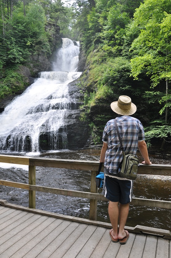
Dingmans Falls in Delaware Water Gap Recreation Area ©Louisa Armbrust Delaware Water Gap National Recreation Area The Delaware Water Gap national Recreation area is 67,00 acres of mountains and valleys, including 40 miles of the Middle Delaware River and 27 miles of the Appalachian Trail. There are waterfalls, rhododendron ravines, and hemlock forests.
Here is the Area website. Phone 570-426-2452
Map AccessibilityDingmans Creek Trail A lovely 0.4 mile one way boardwalk trail takes you past the 80′ Silverthread Falls to Dingmans Falls which drop 130′. The trail is stroller and wheelchair accessible.
McDade Recreational Trail Parts of this trail are accessible, such as Smithfield Beach to Riverview and Bushkill Village to Jerry Lees. However, you should call the park, 570-426-2452 to be sure these sections are appropriate for you.

 Pocono Environmental Education Center has a 1/4 mile rope-lined sensory trail.
Erie National Wildlife Refuge
Here is the Refuge website. Phone: 814-789-3585 Brochure There are five nature trails here. Some of them sound pretty easy. Call to see if they would be easy for you.
Muddy Creek Holly Trail Map “This out-and-back trail stretches a mile over the glacial and riverine sediments of Muddy Creek’s valley. The terrain is flat to gently rolling with an environment of meadows, marshes, oxbow sloughs, and intermediate and mature forests….A four foot wide boardwalk provides excellent access for the handicapped and others in this seasonally wet area.”
 ? Beaver Run Trail is a 1 mile loop? Tsuga Trail can be done as a 1.2 mile loop
John Heinz National Wildlife Refuge at Tinicum
“The refuge protects a variety of habitats for birds in the highly urbanized landscape of greater Philadelphia.”
Here is their website. Phone 215-365-3118 Brochure and Map
Darby Creek. Thank you to Park Ranger Suzanne Kelley who writes that “We have a .6 mile accessible loop – the asphalt path, about 8′ wide, goes between Darby Creek and the impoundment (big man-made pond), crosses the impoundment on a boardwalk and comes back to the visitor center or parking lot through the woods on an asphalt path about 6′ wide. Just past the boardwalk is our accessible fishing deck – the asphalt goes up to it. The visitor center is also accessible…The rest of the service roads and paths are hard packed dirt, gravel. and wood chip. The terrain in general is flat with minor hills towards the center of the refuge.”
State
Pennsylvania State Parks
Here are links to all of the 119 State Parks in Pennsylvania. Note that many trails are described as “Easiest”. This means “elevation gain or loss is minimal, less than 5% slope, maximum 20% up to 100 feet.” It does not guarantee the absence of roots or rocks to trip you up. Call ahead.
Pennsylvania Bureau of State Parks website. Phone 717-787-6640Pennsylvania State Parks with Accessible Trails Thank you Jody Russell of PA Department of Conservation & Natural Resources, Bureau of State Parks for this list “of state parks that have accessible trails and sightseeing areas that are actually marked as accessible or I believe would be suitable for disabled individuals that would like to enjoy Pennsylvania’s state parks.” She has added contact information for each park listed.
Black Moshannon State Park
“Black Moshannon State Park covers 3,394 acres of forests and wetlands and conserves unique, natural environments.” It is surrounded by Moshannon State Forest.
Here is their website. Phone: 814-342-5960 Brochure Map
Bog Trail is “0.3 mile, 0.5 mile full loop, …….Take the boardwalk to explore a wetland dominated by sphagnum moss and leatherleaf, and accented by sedges, rushes, carnivorous plants and lilies. Observe waterfowl and other wildlife along the trail. Wayside panels tell the surprising story of bogs and other park wetlands. Access for people with disabilities is at Boating Area #3.”Cook Forest State Park
8,500-acre Cook Forest State Park in northwestern Pennsylvania., is known for its stands of old growth forest. The park’s Forest Cathedral of towering white pines and hemlocks is a National Natural Landmark. 13 miles of the Clarion River flows through the Park.
Trails Here is the Park website. Phone: 814-744-8407 Map Brochure
Paved Trail: 0.17-mile, “This paved, ADA accessible loop trail is at the end of the water tower access road at the entrance of the Sawmill Center for the Arts. This trail winds through a mature hardwood forest which teams with wildlife like white-tailed deer, squirrel and chipmunk.”Cowans Gap State Park
1.085 acre Cowans Gap State Park is in the Allens Valley of Fulton County. It contains a 42-acre lake and is surrounded by Buchanan State Forest.
Phone: 717-485-3948 Here is the Park website. Brochure Map
 Lakeside Trail: 1.5 miles, “This very pleasant, nearly level, scenic trail encircles Cowans Gap Lake. This is the most popular trail in the park. ” Call ahead to be sure this easy-sounding trail is all right for you.
Gifford Pinchot State Park
2,338-acre Gifford Pinchot State Park is in northern York County. ” The park consists of reverting farm fields and wooded hillsides with the 340-acre Pinchot Lake serving as a prime attraction.”
Phone 717-432-5011 Here is the Park website. Map Brochure
Alpine Trail 0.5 mile, “This wide, flat trail has a gravel surface. Alpine Trail has an outstanding crop of wildflowers in April and May, with bluebells and marsh marigolds. The trail begins on the east side of Conewago Day Use Area.”
Oak Trail 0.4 mile, “This short trail connects the campground to the interpretive center at the western end of the Conewago Day Use Area. The trail is gently rolling and wide with a gravel surface. The trail passes through a maturing oak and hickory forest and past a large diabase rock outcropping near the interpretive center. This trail connects with Gravel and Lakeside trails.
Gravel Trail 1.2 miles, “This trail runs through second growth forest from the campground to the area of the boat rental at the eastern end of the Conewago Day Use Area. This wide trail follows an old woods road and has a gravel surface. ”Jennings Environmental Education Center
The Center is “…dedicated to providing environmental education and interpretation to the community. … One of the park’s main features, the 20-acre prairie ecosystem, is home to distinctive prairie plants and the endangered massasauga rattlesnake.” “Jennings offers many hiking opportunities that traverse varying terrain and diverse habitats. Visitors may walk through over 300 acres of forest and prairie. “
Phone 724-794-6011 Here is the Center’s website. Brochure Map
The park’s brochure describes 13 “easiest hiking” trails which might suit you. Call ahead to be sure.
? Woodwhisper Trail: 0.16 mile, “Popular with people with strollers, this paved, flat loop travels through an upland, mixed hardwood forest.” Not listed as ADA, but call to find out if it will accommodate a wheelchair.Kings Gap Environmental Education Center
“Kings Gap consists of 2,531 acres of forest on South Mountain, with more than 20 miles of hiking trails, a permanent orienteering course, picnicking, hunting, and other recreational and educational opportunities.”
Phone 717-486-5031. Here is the Center’s website. Map Brochure
Whispering Pines Trail: 0.3 mile, paved, “This ADA accessible trail loops through the interior of the pine plantation.”
White Oaks Trail: 0.3 mile, paved,”This ADA accessible loop trail has exhibits to interpret the ecology of a deciduous white oak forest.”
In addition to the wheelchair accessible trails noted above there are several trail described in the brochure as “easiest” hiking.Neshaminy State Park
Neshaminy State Park is along the Delaware River in lower Bucks County.
215-639-4538 Here is the Park website. Brochure
Logan Walk 0.57 miles: “This is the original drive to the former Robert Logan Home, which has been removed. The tree-lined walk is used by visitors for numerous recreational activities and serves as a park service road. The walk is paved and ADA accessible.”
East Walk 0.17 mi. and part of West WalkEagles Forest Trail 0.4 milesRiver Walk Trail (0.92 mile) Oak Lane (0.22 mile), Locust Lane (0.58 mile), Beaver Lane (0.29 mile), and Buck Alley (0.26 mile) trails are all described as “easiest walking”.Norristown Farm Park
“One of the most unique parks in the Pennsylvania state park system, Norristown Farm Park is a working farm in continuous use since colonial times.”
Here is the Park website. Brochure Phone: 610-270-0215 Map
“There are eight miles of trails throughout the park. Most trails are paved and used for walking, rollerblading and bicycling. …All paved trails can be accessed by wheelchairs. Some trails have hills that could impact wheelchair use. Check the contours on the map to determine changes in elevation and your ability to maneuver these grades. ”Ohiopyle State Park
Ohiopyle State Park is c20,500 acres of “rugged natural beauty and serves as the gateway to the Laurel Highlands….” The Youghiogheny River Gorge passes through the center if the park.
Phone 724-329-8591. Here is the Park website. Brochure Map
Youghiogheny River Trail: 27 miles, is part of the150 mile Great Allegheny Passage .
“From the Ramcat Launch Area and Trailhead Parking Area on the east side of the park, the trail descends at a one percent downhill grade to the Train Station/Visitor’s Center parking lot in the town of Ohiopyle. From the Train Station/Visitor’s Center in the town of Ohiopyle, the 17 miles of trail crosses the river twice and descends at a three percent grade to Connellsville. Parking is available in Connellsville in lots on Third Street and in the Yough River Park.Presque Isle State Park
“Presque Isle State Park is a 3,200-acre sandy peninsula that arches into Lake Erie.”
Here is the Park website. Phone 814-833-7424 Brochure
Karl Boyes Multi-purpose National Recreation Trail “makes a 13.5-mile circuit in the park. This paved trail is designated as a National Recreation Trail. This ADA accessible trail is popular with bicyclists, in-line skaters and joggers. During the winter, the trail is plowed from the entrance to the ranger station for hikers.”Sinnemahoning State Park
“Sinnemahoning State Park, located near the center of the Pennsylvania Wilds’ scenic steep valleys region, encompasses 1,910 acres of beautiful scenery and outstanding wildlife habitat.” The Park lies in Cameron and Potter counties and includes lands on both sides of First Fork Sinnemahoning Creek, and a 145-acre reservoir.
Here is the Park website. Phone 814-647-840 Brochure Map
Lowlands Trail 5 miles along “the course of the First Fork …..passing through open fields, shrubby riparian zones and mature, towering forests. “….. Interpretive panels along the way provide insights into the wildlife and ecology of the park. An ADA accessible wildlife viewing platform is located at the northern trailhead of the Lowlands Trail. This area is ideal habitat for deer, elk, woodcock, migratory songbirds and monarch butterflies. The trail from the wildlife viewing platform to the 40 Maples Day Use Area is ADA accessible. A spur of the trail near the 40 Maples Day Use Area leads to a secluded viewing blind that overlooks an abandoned beaver pond. Quiet visitors may be able to see great blue herons wading in the pond or painted turtles basking on partially submerged logs. Osprey, green herons, belted kingfishers, bobcats and whitetail deer also frequent the area.”Swatara State Park
“The 3,520-acre Swatara State Park consists of rolling fields and woodlands situated in the Swatara Valley, between Second and Blue mountains. The scenic Swatara Creek meanders the length of the park and is surrounded by forests and wetlands that support a diversity of wildlife.”
Phone 717-865-6470 Here is the Park website. Brochure
Swatara Rail Trail: 10 miles, “extends from Lickdale Interchange (Exit 90) of I-81 to the Pine Grove Interchange (Exit 100) of I-81. The trail is relatively flat, with variable surfaces: dirt, gravel and pavement.”Tobyhanna State Park
5,440 acre Tobyhanna State Park is in Monroe and Wayne counties in northeastern Pennsylvania and includes 170-acre Tobyhanna Lake.
Phone 570-894-8336 Here is the Park website. Brochure
Lakeside Trail: 5.1 miles, “This improved trail has a hardened base for hiking and bicycling in summer and cross-country skiing and snowmobiling in winter. Although not recommended for people with disabilities, wheelchair users have completed the trail. Part of the trail is on the paved road. ”Varden Conservation Area
The 444-acre Varden Conservation Area is in Wayne County and is protected for future generations as a respite from daily life and a “place to learn about Pennsylvania’s wonderful natural history.”
Here is the Area website. Phone 570-676-3428 Trail descriptions.
Pond Loop Trail 0.73 mile ADA compliant “This trail begins at the teaching pavilion at the Tannery Tract, loops around to Middle Creek, passes through a forested area around a pond, and wraps back to the pavilion.”
Local
Allegheny County Parks
Thanks to Braden Meiter for the following information and suggestions about accessibility in the parks. Here is their website. 412-350-7275
Nextpittsburgh Article by Michele FettingNorth Park Brochure & Map Paved Trails Blazed Trails-Central 724-935-1766 or 724-935-1971
Lake Loop: 5 miles, mostly flat, paved.Swimming pool (south ridge) loops: Paved loops on shoulder of road. Very wide shoulder. As little as .5 miles to about 1.5 miles. Figure eight loops.
Swimming pool (south ridge) loops: Map Blazed trails leaving from Pie Traynor Field. Gravel or wide natural surface, low elevation change. Suggested Route: Head south from Pie Traynor parking lot onto trail with white with red dot blaze. Follow to intersection with South ridge road. Make right turn onto white blaze trail. Follow to Pie Traynor parking lot.
[ Latodami Nature Center trails Phone 724-935-2170
 Nature Access Trail map 0.4 mile Braille trail]
Hartwood Acres Park Map Basic Trail Map Detailed Trail Map 412-767-9200
Mansion parking lot: Wide, mostly flat, natural surface. Cross street from parking lot. Follow trail #10 until it meets an unmarked intersection, bear in the sidebar. Trail intersects with purple trail (trail 12), go right. Stay straight through intersections until back at trail beginning.Deer Lakes Park Map 724-265-3520
Paved Pond Trails: Paved, mostly flat. Loops starting from Splash park or Veterans Shelter Parking lots. Distance variable.Harrison Hills Park Map Map of Blazed Trails 724-295-3570
Paved loop at CottonTail Drive Playground: Flat, paved, 0.5 mile .Environmental Learning Center Loop: Mostly flat, wide, natural surface trail, approximately 1 mile. Park at ELC. Walk north on gravel service road. Turn right onto purple trail through meadow. At intersection with green trail, turn right and follow back to service road. Turn left back to ELC parking lot.South Park north half of Map south half of Map Trails 412-835-4809 or 412-835-4810, or 412-835-5710
Corrigan Drive: flat, paved. Couple different parking locations, not a loop; out and back. 2 Miles.
Maple Springs Road Exercise Loop: flat, rock/gravel, some paved spots. 1.75 Miles.Round Hill Park Map Trails- Not Blazed 412-384-4701
The Farm: Everything around the farm is paved and loops all around to the different animals ( .5 miles).
The trails here are not blazed, would be difficult to explain. Some trails, however, are flat around the farm , as they are also accessed by tractors/other farm equipment.White Oak Park Map 412-678-3774 or 412-350-2455
Sylvan Drive: It is a paved road that comes to a dead end, main park road, which most of the shelters are on. There is rarely heavy traffic and safe for most park visitors. Very popular for walking.Settlers Cabin Park Map
Panhandle Connector Trail: Leaves from the old park office on Greer Rd. Trail is completely paved and is 0.67 mile long – eventually it will connect to the Panhandle Trail once property is acquired.
Panhandle rail trail is nearby: http://www.railstotrails.us/pa_panhandle_trail.htmBoyce Park Map Trails Map 724-327-0338 or 724-327-8798 Visitor Center 724-733-4618
Centerview Drive: Paved, mostly flat, some hills. Variable distances depending on parking.Wide paved berm with light traffic.
Trail from Silver Beaver: Old road, paved but is not a loop.Asbury Woods
Asbury Woods is an independent non-profit organization with a mission “to provide all members of the community with meaningful environmental, educational and recreational experiences…”
Here is their website. 814-835-5356 Trail Guide Trail Map
Boardwalk Trail 1/3 mile located just behind the Nature Center. Trail features include mature woods, access to a quiet gazebo and a wetland deck where visitors can see summer dragonflies, turtles, ducks and more.Bucks County Parks and Recreation
Bucks County has eight parks, eight recreation areas and three nature centers.
Here is their website. Phone215-348-6114 or 215-757-0571
Churchville Nature Center Trail Map 215-357-4005
Thank you to Kirsten Becker, who supplied the map and this trail information: “We have one small section of trail, our yellow trail, that is paved that loops around our meadow and over to our pond, as well as a small section that has a board walk near that. The remainder of the trails (2 miles total) are hard packed dirt. One of our trails, the orange trail does have a great deal of exposed roots through one section. Our building is accessible. ”
Silver Lake Park 215-757-0571 Nature Center
“A half mile double loop is handicapped accessible and can be reached from the Visitor Center or from the parking lot by the lake.”
Lancaster County
Parks, Trails, & Map 717-299-8215 Here is the County website.
Central Park Trails and facilities brochure and map
Conestoga Greenway Trail 1.3 miles paved pathway “that runs along the outer bank of the Conestoga River as it encircles the Sunnyside peninsula.” It “provides educational opportunities to study the riverway itself, as well as the wildlife and flora and fauna that call it home. ”
Conewago Recreation Trail 5.5 miles which “follows the Conewago Creek through scenic farmland and woodlands, and links to the Lebanon Valley RailTrail. ” Note, when I posted this in March 2016, there was a warning on the website that some sections of this trail are washed out.
Lancaster Junction Recreation Trail “runs for 2.3 miles between the hamlet of Lancaster Junction and Route 283. Like the Conewago Trail, Lancaster Junction Trail travels through some of Lancaster County’s most scenic farmland, and borders Chiques Creek in its northern half.”
Both Conewago and Lancaster Junction trails have “well-graded, level surfaces.”
? The Northwest Lancaster County River Trail Parts of this “fourteen-mile, multi-use, public recreation trail adjacent to the Susquehanna River” are accessible for wheelchairs, but not all. Call the county, the borough, or township numbers given in the website for information.
Private
Bucks County Audubon Society at Honey Hollow
Honey Hollow has 1″10-acres with 6 miles of trails, meadows, forests, ponds, wetlands, and streams. Visit our Healing Garden, Explore the Honey Hollow Creek and Pond, and Discover our Agricultural Fields!”
Here is their website. Phone 215-297-5880 Trail Map
Diane Smith, Educational Director, writes, “We have one trail that I consider accessible (although maybe not fully ADA compliant), our Visitor Center is accessible and some trails are very easy.”“On the …. map, trail L, Bird Blind or Lavender trail is accessible. ““All of the trails in the bluebird meadow (M, pink) are easy, as are some of the approaches to the pond (G, green). None of the trails are paved but the easy/accessible ones are smooth, grassy and not steep.”Conemaugh River Lake
“An abundance of cultural resources and recreational opportunities coupled with a great river revival and trail has certainly made Conemaugh River Lake the place to be for outdoor fun!”
Here is their website. 724-639-9013 option: 7 Maintained by the Conemaugh Valley Conservancy
West Penn Rail Trail “Interpretive signs along the trail point out interesting parts of the historical legacy. Over three miles of the [17 mile] trail is level and accessible by wheelchair at the Livermore and Westinghouse trail heads.” Call before you go. There is a note on the Map that the access at Westinghouse is closed.Hawk Mountain Sanctuary
“Hawk Mountain Sanctuary is the world’s first refuge for birds of prey and an international center for raptor conservation. Our 2,600-acre mountaintop preserve offers incredible scenic overlooks, eight miles of trail, a Visitor Center, native plant garden, and the Acopian Center for Conservational Learning.”
Here is the Sanctuary website. (610) 756-6961 Accessibility Trail Map slide show of Lookout Trail
Thanks to Annie Trexler who writes that “the native plant garden, bird blind and south lookout are all now wheelchair accessible.”
The Lookout Trail to South Lookout is 900 feet long with a grade of less than 8.3 percent, ….. Most areas are even less steep and overall, the trail averages an 8 percent grade. …Bench seating with pull bars are located every 100 feet….Trail connects to the Laurelwood Niche, a secluded area for education programs and designed to provide space for a wheelchair or stroller. The South Lookout includes a smooth, flat, and natural viewing area with one bench with pull bar. Nearby are two additional benches that offer a place to rest. Binoculars are recommended at all Lookouts.
The Native Plant Garden features a brick walkway that is accessible by wheelchair. The pathway makes a short loop and includes a viewing deck over a small pond. Gates are opened during the daytime hours.Pennypack Ecological Restoration Trust
“The Trust maintains “..almost 11 miles of trails in the Preserve open free to the public to explore and enjoy the natural world all year long.”
Here is the Trust website, Phone 215-657-0830 Trails
Thank you to David Robertson for the following information:
“The Pennypack Parkway (between Mason’s Mill Road and Pennypack Road) is very accessible for disabled visitors. It was an old, flat, level road that is now abandoned and surfaced with crushed stone grit. It may have a few minor erosion rills in places, but I recommend it to people in wheelchairs and families with children in strollers.”
“Montgomery County’s new Pennypack Trail, a rails-to-trails project created on the bed of the old Fox Chase-Newtown regional rail line, parallels the Creek Road Trail on the east side of the creek. That trail is flat, even, and level–perfect for disabled users. It is heavily used. The Pennypack Trust does not maintain that trail; it is the responsibility of Montgomery County, and it extends southward to the county’s Lorimer Park for a total length of just over 5 miles.”
?? “The Creek Road Trail, also an old abandoned road, is subject to flooding because it is located so close to the creek. While the trail is mostly flat and level, the surface is very, very uneven. In places, it is gravel, in other places it is paved, and in still other places it has washed out down to the ballast under the asphalt. I wouldn’t recommend it for a disabled person.”The Schuylkill Center
“With 340 acres and over three miles of hiking trails, we welcome visitors to explore our forests and fields, our ponds and streams.”
Here is the Center’s website. Phone 215-482-7300 Trails Trail Map
Widener Trail 0.25 miles, paved. The trail “leads through fields and forest to the Widener Bird Blind. Feeders are filled year-round so you can observe local and migrating birds. Midway along the trail is Shadow Bog with a wooden deck and seating area.”
Hagys Mill Road 0.3 mile is flat. Call first to be sure of conditions.
Miscellaneous
American Trails has links to information about many trails in Pennsylvania.
Delaware & LeHigh National Heritage Corridor
From Wikipedia: “The D&L Trail is a 165-mile (266 km) multi-use trail. The trail incorporates rail trails, rails with trails, share-the-road sections, and canal towpaths…The trail follows the route that anthracite coal took from mine to market. It winds through northern mountains and along the banks of the Lehigh and Delaware Rivers through northeast Pennsylvania, the Lehigh Valley, and Bucks County. The D&L Trail passes through towns, industrial powerhouses, and along remnants of the Lehigh and Delaware canals. This earthen path exposes walkers, hikers, bicyclists, and others to Pennsylvania wildflowers, waterfalls, and wildlife.” The corridor crosses may state, county and local parks.
Here is their website. Map
Lehigh Canal North from TrailLinks
Lehigh Canal South from TrailLinks
Walnutport to Weissport from TrailLinksExplorePAtrails.com is a searchable site where you can put in your parameters such as hiking, length and distance from a city or zip code and it will come up with a list with links to information about trails. For example, I chose within 100 miles of Allenstown, any length, hiking, and wheelchair and it turned up 72 ADA trails!
Great Allegheny Passage
“Now the longest rail-trail east of the Mississippi River, the 150-mile Great Allegheny Passage (GAP) spans two states in its course along great rivers and across mountain passes. Running from Pittsburgh, Pennsylvania, to Cumberland, Maryland, the trail traces the paths of railroads that helped build America.” Here is the website. Described in TrailLink. Trail Grade and Surfacebelieve@Magee from the Magee Rehabilitation Hospital has this great page with information on wheelchair accessible trails..
Nature For The Blind has a directory of Braille trails for almost every state in the US and for many other countries.
The Rails-to-Trails Conservancy lists wheelchair accessible trails in Pennsylvania.