
Ohio has a number of trails with minimal obstacles. Some are very easy and others are wheelchair accessible. Here are just a few of them.
Ohio has an amazing wealth of parks and trails. Their management is a little confusing and there is some overlap between the federal, state and metro parks. These links were found through Internet search. I would love to have first hand recommendations from other people. With your help, we can share our knowledge with disabled people everywhere and also increase awareness of the need for more accessibility. Please e-mail me with your suggestions using the form in the sidebar.
Federal
State
Local
Private
Miscellaneous
Federal
Cuyahoga Valley National Park
Cuyahoga Valley National Park “…is a refuge for native plants and wildlife, and provides routes of discovery for visitors. The winding Cuyahoga River gives way to deep forests, rolling hills, and open farmlands.” Here is their website.
Accessibility Maps Special Needs Brochure Trails Phone 330-657-2752
 There are a great many “easy” hikes in Cuyahoga Valley National Park. Too many for me to list. Call the park’s accessibility coordinator, Arrye Rosser, at 440-546-5992 for help determining which paths are suitable for your limitations.
Here is Wheelchairtraveling.com’s excellent and thorough access guide to the park.
 Ohio & Erie Canal Towpath Trail Map including Beaver Marsh. The path is 19.5 miles and has ten trailheads. Beaver Marsh has an audio station with educational messages for people with visual limitations. Beaver Marsh Brochure
Brandywine Falls Map The first 1/8 mile is accessible to the first boardwalk overlook.
State
Ohio State Parks Accessible facilities, including trails
Ohio has about 58 state parks with hiking trails. At least five have accessible paved or boardwalk trails. Please let me know of easy (but not necessarily wheelchair accessible) hikes that I should include for hikers not restricted to wheelchairs, but needing easy footing.Adams Lake State Park
“Located in Ohio’s Bluegrass region, one of the state’s most scenic and biologically interesting areas, Adams Lake State Park has much to offer the nature enthusiast. Remnant prairies and a quiet lake can be enjoyed in this small (50-acre) unique park.”
Park Office (Rocky Fork): (937) 393-4284 Here is their website. Map
There is an accessible 3/4 mile path along the southern shore of Adams Lake.Cedar Bog State Nature Preserve
Cedar Bog State Nature Preserve, four miles south of Urbana in Champaign County, is a National Natural Landmark. More than forty endangered, threatened, and rare plants and animals are found in its 450 acres. This preserve is operated by the non-profit Cedar Bog Association and is owned by the Ohio History Connection. There is a $5 per person admission fee. Here is a description from the Ohio Division of Natural Areas and Preserves.
Their phone number is 937-484-3744.
The boardwalk, 1.2 miles, has been built to ADA specifications and is fully wheelchair accessible. Thank you Mike Crackel for letting me know about it.Hocking Hills State Park
Hocking Hills “features towering cliffs, waterfalls and deep, hemlock-shaded gorges for hikers and nature lovers to enjoy and serve as a backdrop to popular facilities and accommodations.” Some information on the web pages is inconsistent. Before going it would be wise to call 740-385-6842. Here is their website. Hocking Hills.com Park Map Trails Map Maps of Trails
Conkles Hollow Brochure Map The Lower Gorge Trail is 1 mile and accessible.
There is a “deep, cool gorge, which is only 100 feet wide in places and is considered by some to be the deepest in Ohio” There are has “numerous waterfalls cascading over its sandstone cliffs.”
 Ash Cave Gorge has an 1/4 mile accessible trail. “Ash Cave is the largest, most impressive recess cave in the state.”
? Cantwell Cliffs 1/4 mile of the Cantwell Cliffs Gorge trail is said to be accessible, but call first as the rest of the 1 mile trail is rated “difficult.”
? Old Man’s Cave HockingHills.com claims that 3/4 mile of the Gorge trail here is wheelchair accessible. However, the park site says the 1 mile trail is “moderate” and does not mention accessibility.Little Miami State Park
Caesar Creek Park Office: (513) 897-3055 North of Hedges Road Here is their website. Phone 937-376-7440 Park Map
Little Miami is a 50 mile long paved trail corridor created from an abandoned railroad right-of-way along the Little Miami River. “As the river twists and bends, visitors will discover many natural wonders such as steep rocky cliffs, towering sycamores and elegant great blue herons on the wing.”Ohio State Nature Preserves Accessible Nature Preserves Call the Ohio Department of Natural Resources 614-265-6565 for more information.
There are 136 State nature Preserves and natural areas in Ohio., “Most…contain small parking lots and a trail system.” “Restrooms, picnic facilities and areas for active recreation are generally not available.” Some are within State Parks and are described under that heading.
Blackhand Gorge Brochure Photographs on this website show a paved path and it is listed as having an ADA trail. This is probably the four mile bike trail, part of which is currently (10/2015) under repair.
Cooperrider-Kent Bog Brochure The 0.5 mile boardwalk leads you through this “living relect from the Ice Age.”Quail Hollow State Park
Call the park for more information about their trails: 330-877-6652. Here is the Park website. Park Map Trail Map
“The Nature For All trail is a 2000-foot paved interpretive trail for those visitors with a physical challenge.”
This park has eight interpretive nature hiking trails. The longest are 1.5 miles and all are rated “Easy”.
Local
Cleveland Metroparks
Links to maps and information about the 16 Reservations with hiking and walking trails. Links to the Nature/Visitor Centers. Note that by “reservation” they are referring to land set aside for conservation purposes. “Trails exist in every reservation with a variety of vistas and terrains, and can be located by contacting a Cleveland Metroparks naturalist at one of the seven outdoor education facilities.” Here is the Metroparks website. For Park Administration call 216-635-3200
Big Creek Reservation Map Trail Map
Lake to Lake Trail “a 2.4 mile, universally accessible all purpose trail that connects Lake Abram to Lake Isaac. On foot, by bicycle, or by wheelchair, one crosses Abram Creek and Bagley Road as they travel the trail that passes through 175 acres of headwater wetlands joining the largest kettle lakes in Cuyahoga County.”
There are several “easy” trails listed. Call Park Administration to learn more.
Edgewater Beach is an urban park located between the Memorial Shoreway and Lake Erie.”
A free ADA Beach Wheelchair is available for use on a first come, first served basis while lifeguards are on duty.
North Chagrin Reservation Map North Chagrin Nature Center 440-473-3370
“The Nature Center overlooks Sanctuary Marsh, where native plants create a fine wetland community attracting a host of waterfowl, mammals, insects, reptiles, amphibians, songbirds and shorebirds. Marsh wildflowers bloom throughout the spring and summer.” “The trails surrounding North Chagrin Nature Center are paved for easy access to all visitors.”Columbus and Franklin County Metro Parks
Many of the Metro Parks have trails rated “easy”. Call to see if they would be easy for you. Here is their website.
Battelle Darby Creek phone 614-370-6254 or Nature Center 614-878-7106 Trails
“Battelle Darby Creek features more than 7,000 acres of forest, prairies and wetlands. It stretches along 13 miles of the Big and Little Darby creeks, both State and National Scenic Rivers. ……. there are also over 1,600 acres of restored wetlands and prairies. ”
Darby Creek Greenway 4.7 miles. “Flat trail through the prairies and woods that intersects the two bison pastures.”
Blacklick Woods Map Trails phone 614.861.8759 There are six trails here, All of them ADA!
Beech Trail 0.5 miles. “Passes through a beech-maple forest with beautiful displays of spring wildflowers, and continues past a swamp forest area.”
Maple Loop 0.9 miles “Good for birding, traversing hardwood forest and passing a small wetland.”
Multipurpose Trail 4.1 miles “Passes through a forest and a meadow.”Blacklick Creek Greenway 18 miles. “Connects three Metro Parks and several small parks from Reynoldsburg to Groveport.”
Buttonbush Trail 0.5 miles. “Runs through a hardwood swamp forest.”Walter A. Tucker Trail 0.1 miles “Links the Buttonbush and Maple trails.”Blendon Woods Trails phone 614-620-1861 or nature center 614-895-6221
? There are six trails here rated “easy”. I suggest you call to see if they are suitable for your limitations.
Glacier Ridge Trails Map phone 614-216-8859
Ironweed 2.8 miles “Goes through woods and fields and leads to Honda Wetland Education Center.”
Marsh Hawk 3 miles paved “Goes through woods and fields.”Highbanks Trails Map phone 614-906-3149 or the Nature Center at 614-846-9962
Big Meadows Path 1 mile paved path “through meadows and playfields.”Scenic River 0.6 miles ” goes through forest and along the Olentangy river.Prairie Oaks Trails Map phone 614-208-4321
Darby Creek Greenway is 3.4 miles and “winds through Darby Bend Lakes area and crosses Big Darby Creek.”
Scioto Audubon Trails Map phone 614-202-5197
Scioto Greenway 2 miles paved path that “stretches along the Scioto River and links the southern and north section of the greenway trail.”
Sharon Woods Trails Map phone 614-620-1865
Edward S Thomas 1.1 miles which “winds through a state nature preserve and past large burr oaks and an observation deck. ”
Multipurpose 3.8 miles “loops around the park and passes through woods and fields.”Slate Run Trails Map phone 614-329-1392
Bobolink grassland 1.5 miles “winds through grassland and leads to an observation deck overlooking the wetlands.”
Three Creeks Trails Map phone 614-208-2874
Alum Creek Greenway 7.3 miles paved path which “runs alongside Alum Creek and crosses a 300-foot bridge below the confluence of the Alum, Big walnut and Blacklick creeks.”Summit County Metro Parks
Summit County maintains many parks and trails. Here is a website with links to maps of each of the parks as well as the Freedom and Towpath Trails.
Call 330-865-8065 for information. Here is the Parks website.
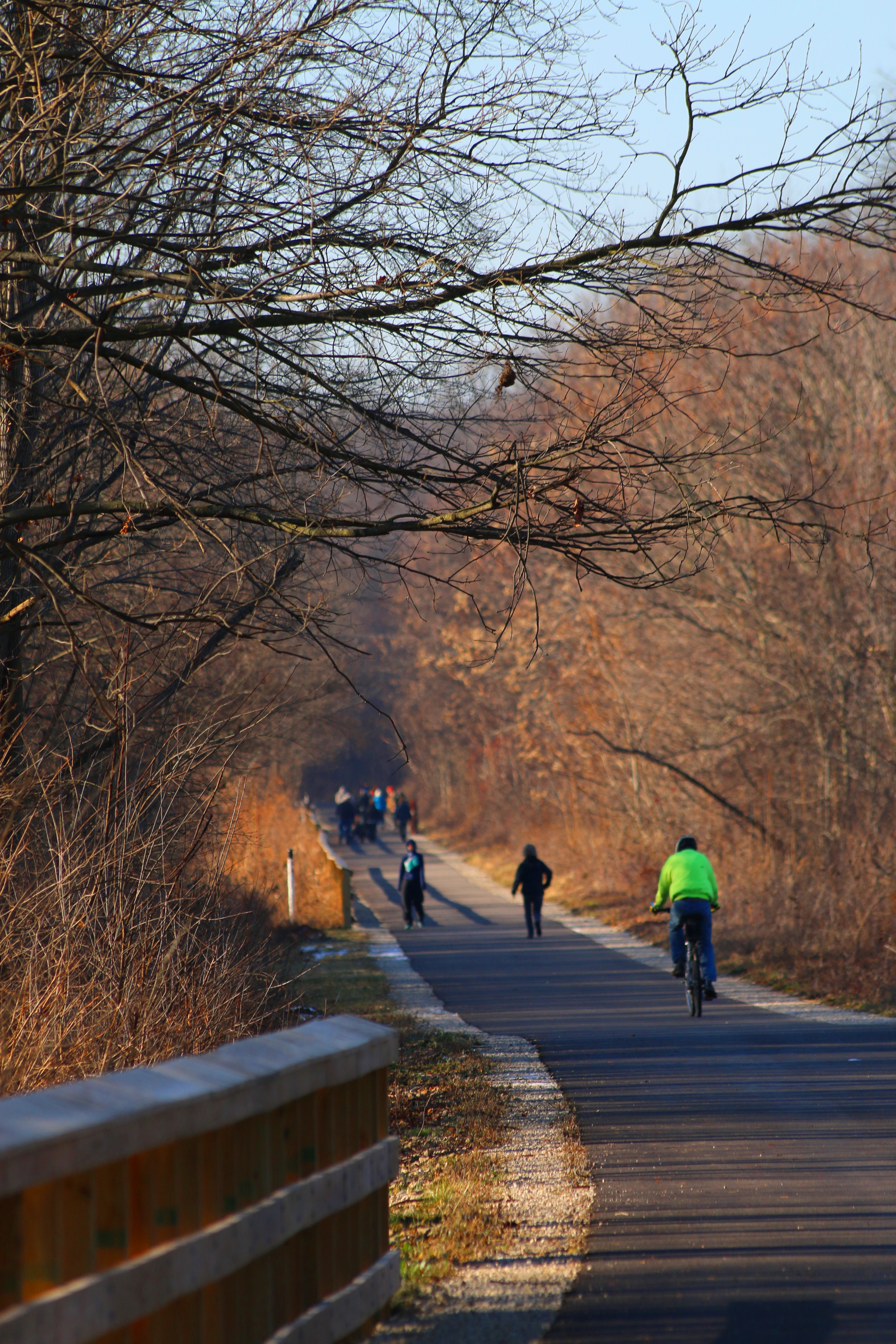
List of accessible trails This list has 11 paved trails, 10 of which are in natural areas.Freedom Trail 6.2 miles between Middlebury Lot to Westwood Avenue in Akron.Ohio & Erie Canal Towpath Trail 85 miles – mostly ADA accessible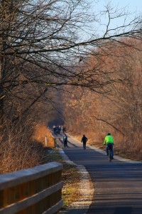
Freedom Trail Photo courtesy of Summit Metro Parks. 
Towpath Trail photo courtesy of Summit Metro Parks
Private
Miscellaneous
Nature For The Blind has a directory of Braille trails for almost every state in the US and for many other countries.
The Rails-to-Trails Conservancy lists wheelchair accessible trails in Ohio.