Roosevelt National Forest
The Canyon Lakes Ranger District of the Roosevelt National Forest in north central Colorado includes the Pawnee National Grasslands, Pingree Park, the Red Feather Lakes area and Big Thompson and Estes Park. The Poudre Wilderness Volunteers post an informative website describing these areas. Phone for the Canyon Lakes Ranger District is 970-295-6700.
Pawnee National Grasslands I have a separate post about this area. Look for it above this post.
Pingree Park contains Colorado State University’s Mountain Campus. Map
![]() Comanche Lake 1.1 miles to the lake, 1.6 miles if you go around the lake. Here is a detailed description of the trail.
Comanche Lake 1.1 miles to the lake, 1.6 miles if you go around the lake. Here is a detailed description of the trail.
Red Feather Lakes
![]() Lady Moon Trail is 2.6 miles between the two trailheads, but you may just want to hike a mile or mile and a half from the Elkhorn Creek Trailhead. Half a mile from the Lady Moon trailhead and about 1.5 miles from the Elkhorn Creek trailhead the trail takes an elevation gain which may be more strenuous than you want. Here is a description.
Lady Moon Trail is 2.6 miles between the two trailheads, but you may just want to hike a mile or mile and a half from the Elkhorn Creek Trailhead. Half a mile from the Lady Moon trailhead and about 1.5 miles from the Elkhorn Creek trailhead the trail takes an elevation gain which may be more strenuous than you want. Here is a description.
![]() Mt. Margaret Trail 3.8 miles downhill! to the summit You may want to just hike the first 1.5 miles to avoid an uphill return. Most of this trail is on an old roadbed . Forest Service description. Location Map Described on AllTrails and on HikingProject.
Mt. Margaret Trail 3.8 miles downhill! to the summit You may want to just hike the first 1.5 miles to avoid an uphill return. Most of this trail is on an old roadbed . Forest Service description. Location Map Described on AllTrails and on HikingProject.
You can gain access to the easy-sounding Columbine Trail Complex from the Mt. Margaret trail, but that is probably a longer hike than you want to take. These trails are also mostly old roads.
Here is a map of the Red Feather Lakes area.
Lily Mountain
![]() Lily Mountain Trail is pretty level for the first mile before climbing over 800′ to the summit in just one more mile. Description Road map showing the trailhead.
Lily Mountain Trail is pretty level for the first mile before climbing over 800′ to the summit in just one more mile. Description Road map showing the trailhead.
Author: Cecilia
Pawnee National Grassland
Pawnee National Grassland
The Pawnee National Grassland in northeast Weld County, Colorado is part of the Roosevelt National Forest and has the accessible Trail of the Mourning Dove and a Birdwalk in the Crow Valley Recreation Area. The grassland is a part of the short grass prairie and a fine location for spring wildflowers and for birding. Wildlife includes pronghorn, bison, prairie dogs and many others. The Buttes, which rise about 300 feet above the plains are erosional remnants of the High Plains. They consist of the soft clay-rich Brule formation overlain by the sandstone and conglomerates of the Pawnee Creek and the Arikaree formations.
Be sure to call ahead to learn of trail conditions and of seasonal closures. Here is the website. Phone 970-834-9270 Map
Crow Valley Recreation Area
![]() Trail of the Mourning Dove Short trail from the Steward J. Adams Education Site along the usually dry Crow Creek”
Trail of the Mourning Dove Short trail from the Steward J. Adams Education Site along the usually dry Crow Creek”
![]() Birdwalk Trail Short walk across a dry creek bed and into a cottonwood stand.
Birdwalk Trail Short walk across a dry creek bed and into a cottonwood stand.
Pawnee Buttes Trail
![]() 1.5 mile trail to the first butte and 2.1 mile to “slightly beyond the eastern base of the western Pawnee Butte. The trail is rated easy or “easy to intermediate” depending on which reference you find. Here is a detailed description. Call ahead to learn more.
1.5 mile trail to the first butte and 2.1 mile to “slightly beyond the eastern base of the western Pawnee Butte. The trail is rated easy or “easy to intermediate” depending on which reference you find. Here is a detailed description. Call ahead to learn more.
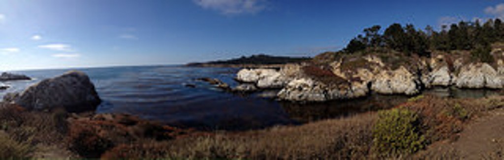
Point Lobos, CA
Point Lobos State Nature Reserve
Point Lobos State Nature Reserve has five accessible trails ranging in length from 0.25 to 0.5 miles. The Reserve is remarkable for the “…rare plant communities, endangered archeological sites, unique geological formations, and incredibly rich flora and fauna of both land and sea….This area contains headlands, coves and rolling meadows.” Wildlife includes thousands of seabirds, seals, sea lions, sea otters and migrating gray whales (from December to May). Thank you to Lane Davis for letting me know about Point Lobos and for the photograph.
Phone 831-624-4909 Here is their website. Here is lots of helpful information from the Point Lobos Foundation. Accessible Features
![]() Cypress Grove Trail 0.25 mile with views of the cove.
Cypress Grove Trail 0.25 mile with views of the cove.
![]() Sand Hill Trail, 0.4 mile paved loop leading to views of the cove.
Sand Hill Trail, 0.4 mile paved loop leading to views of the cove.
![]() Carmelo Meadow Trail 0.3 mile compacted soil “…winds through native Monterey Pine forest and terminates at Whalers Cove.”
Carmelo Meadow Trail 0.3 mile compacted soil “…winds through native Monterey Pine forest and terminates at Whalers Cove.”
![]() Granite Point Trail 0.36 mile compacted soil “…hugs the Whalers Cove bluff offering spectacular views of the coastline and its abundant wildlife.”
Granite Point Trail 0.36 mile compacted soil “…hugs the Whalers Cove bluff offering spectacular views of the coastline and its abundant wildlife.”
![]() Bird Island Trail 0.5 mile “…provides views of Bird Island and China Cove where visitors can watch harbor seals nursing new born pups.”
Bird Island Trail 0.5 mile “…provides views of Bird Island and China Cove where visitors can watch harbor seals nursing new born pups.”
Mono Lake Tufa State Natural Reserve
Mono Lake Tufa State Natural Reserve
Mono Lake Tufa State Natural Reserve has accessible trails and boardwalks The Reserve is 13 miles east of Yosemite National Park and is near the town of Lee Vining. 65 square mile Mono Lake is over 1 million years old, making it one of the oldest lakes in North America. It is famous for its tufa towers, calcium-carbonate spires and knobs formed by interaction of freshwater springs and alkaline lake water. The reserve protects the lake and the wetlands and other sensitive habitat for the 1 – 2 million birds that feed and rest at Mono Lake each year.
Here is their website. Information on Accessibility. Phone 760-647-6331
![]() South Tufa Interpretive Trail 0.25 mile self-guided trail to the shore and through the tufa towers. The first 0.25 mile is wheelchair accessible and the hard-packed soil beyond is easy walking.
South Tufa Interpretive Trail 0.25 mile self-guided trail to the shore and through the tufa towers. The first 0.25 mile is wheelchair accessible and the hard-packed soil beyond is easy walking.
![]() Boardwalk Interpretive Trail 0.5 mile gives access to the north shore tufa areas and marsh.
Boardwalk Interpretive Trail 0.5 mile gives access to the north shore tufa areas and marsh.
![]() Lake Trail 0.35 mile through the wetland to the shore.
Lake Trail 0.35 mile through the wetland to the shore.
Inyo National Forest
Inyo National Forest
Inyo National Forest in the Eastern Sierra of California has some easy and some accessible trails and boardwalks such as the Nunatak Tioga Tarns Trail and the Convict Lake Loop Trail. Thanks to Debra Schweizer for letting me know about them. The 1,903,381 acre Inyo National Forest includes many of California’s iconic locations such as Mt. Whitney, Mono Lake, Mammoth Lakes, the John Muir Wilderness, and the Ancient Bristlecone Pine Forest.
Phone 760-873-2400 Here is their website. Visitor Guide
Mono Lake Ranger District
![]()
![]() ? Nunatak Tioga Tarns Trail 0.5 mile There are interpretive signs along this trail. Ms Schweizer writes that it may have been ADA compliant when it was originally built but has not been maintained. She has seen wheelchair users on it, but they had assistance.
? Nunatak Tioga Tarns Trail 0.5 mile There are interpretive signs along this trail. Ms Schweizer writes that it may have been ADA compliant when it was originally built but has not been maintained. She has seen wheelchair users on it, but they had assistance.
![]() Mono Lake Boardwalk, South Tufa 0.7 mile easy boardwalk through the tufas. From the photos it looks narrow for wheelchairs, but call the Visitor Center for information 760-647-3044 See also Mono Lake State Natural Reserve under the State listings on this page.
Mono Lake Boardwalk, South Tufa 0.7 mile easy boardwalk through the tufas. From the photos it looks narrow for wheelchairs, but call the Visitor Center for information 760-647-3044 See also Mono Lake State Natural Reserve under the State listings on this page.
Mammoth Ranger District
![]() Convict Lake East Shore Trail a short paved nature trail from the outflow of Convict Lake to the picnic area at the base of Mt. Morrison.
Convict Lake East Shore Trail a short paved nature trail from the outflow of Convict Lake to the picnic area at the base of Mt. Morrison.
![]() Ms Schweizer mentions the bike trails at Mammoth Lakes area. Here is a link to descriptions of these paved, “family friendly” biking trails.
Ms Schweizer mentions the bike trails at Mammoth Lakes area. Here is a link to descriptions of these paved, “family friendly” biking trails.
White Mountain Ranger District.
![]() Schulman Grove Visitor Center in the Ancient Bristlecone Pine Forest. Ms Schweizer writes that there is a short boardwalk that gives access to the visitor center and has displays about the ancient trees.
Schulman Grove Visitor Center in the Ancient Bristlecone Pine Forest. Ms Schweizer writes that there is a short boardwalk that gives access to the visitor center and has displays about the ancient trees.
Know more about Inyo National Forest?
Have you visited this location and know of more accessible or easy trails? Is any of the information given here incorrect? If so, please contact me using the form to the left and let me know what should be changed or added so I can update this post.
Green Swamp Preserve
Green Swamp Preserve
The Green Swamp Preserve in Brunswick County, North Carolina has an easy trail running through it. The 17,424 acre preserve, owned by the Nature Conservancy, “…contains some of the country’s finest examples of longleaf pine savannas. The open savannas have a diverse herb layer with many orchids and insectivorous plants. Almost 13,000 acres of the preserve, however, are comprised of a dense evergreen shrub bog (pocosin) dominated by gallberry, titi, and sweetbay.” Phone 910-395-5000 Here is their website. Described on North Carolina Birding Trail Thank you to Bill Blevins are letting me know about this preserve.
![]() The trail is 1 1/2 mile round trip and flat. “A small portion of the trail is boardwalk through thick shrubs. The board walk can get quite slippery, so be careful.” Closed-toe waterproof shoes are advised.
The trail is 1 1/2 mile round trip and flat. “A small portion of the trail is boardwalk through thick shrubs. The board walk can get quite slippery, so be careful.” Closed-toe waterproof shoes are advised.
Florida Tech Botanical Garden
Florida Tech Botanical Garden – accessible, easy
The over twenty acre botanical garden at Florida Tech in Melbourne is free and open to the public. There are more than 200 palms, bamboos and many other plants amidst winding streams in this lush setting. Michelle Mulak in Florida Today writes that, “The trail has both paved and unpaved sections, with some small bridges and uneven terrain. When dry, this would be suitable for wheelchairs and strollers. When wet, wooden surfaces become slippery, and low-lying sections will flood. Most of the trail is shaded.” Thank you to Bill Blevins for letting us know about the garden. Phone 321-674-803 Virtual Tour Map
Their website Description and Self Guided Tour at plantsmap.com.
![]() 1.25 mile Dent Smith Trail. See comment above about the trail when it is wet.
1.25 mile Dent Smith Trail. See comment above about the trail when it is wet.
Spotsylvania County
Ni River Trail
The Ni River Trail is an easy and partially wheelchair accessible trail near Fredericksburg, Virginia. It is maintained by the Spotslyvania Greenways Initiative. Location as described on Fredericksburg.com is “behind River Run Business Park off U.S. 1, across from Massaponax High School. It’s on land owned by Luck Development Partners and has a half-mile handicapped-accessible path covered with stone dust. ”
![]() ? The Salamander Loop of the Ni River Trail is about 2 miles long and loops past a wetland area and an old farm pond and includes an overlook of the Ni River basin. Local fauna include deer, beavers, foxes, birds and salamanders. Thank you to Bill Blevins for this description, “…Open to public. Fairly well groomed and wide trail through the woods. Many labeled trees along the path. There is a short loop and a longer loop with a spur trail along the river when it is not hunting season. I would say not accessible to wheelchairs but it is easily walked. There are 6 designated parking spots at the trailhead.” Here is a description by Plants Map. Video
? The Salamander Loop of the Ni River Trail is about 2 miles long and loops past a wetland area and an old farm pond and includes an overlook of the Ni River basin. Local fauna include deer, beavers, foxes, birds and salamanders. Thank you to Bill Blevins for this description, “…Open to public. Fairly well groomed and wide trail through the woods. Many labeled trees along the path. There is a short loop and a longer loop with a spur trail along the river when it is not hunting season. I would say not accessible to wheelchairs but it is easily walked. There are 6 designated parking spots at the trailhead.” Here is a description by Plants Map. Video
Nature For The Blind
Nature For The Blind has a directory of Braille trails for almost every state in the US and for many other countries.
Nature For The Blind
Nature For The Blind has a directory of Braille trails for almost every state in the US and for many other countries.