Settlers Cove State Recreation Site
Settlers Cove is a quiet spot on the Clover Passage in the Ketchikan Region of Southeast Alaska. Red Cedar, Western Hemlock and Sitka Spruce grow here in the temperate rainforest. There is a sandy beach and a series of trails. Their website. Phone 907-465-4563
![]() Hollow Cedar Beach Access Trail 200 yds to Lunch Creek Bridge
Hollow Cedar Beach Access Trail 200 yds to Lunch Creek Bridge
Author: Cecilia
Old Sitka State Historical Park
Old Sitka State Historical Park
A settlement here along Starrigavan Bay was built by Russians in the early 1800s. This site has been designated as a National Historic Landmark and there are interpretive panels with information about the history here. The park is 7 miles north of downtown Sitka. Here is their website.
![]() Forest and Muskegs Trail 1.25 self-guided mile “…hard-pack gravel, with sections of boardwalk. Approximately 100 feet of trail has a 14% gradient. The rest of the trail has a gradient of 12% or less.”
Forest and Muskegs Trail 1.25 self-guided mile “…hard-pack gravel, with sections of boardwalk. Approximately 100 feet of trail has a 14% gradient. The rest of the trail has a gradient of 12% or less.”
Interpretive Panels Map Phone 907-269-8400
Lake Louise State Recreation Area
Lake Louise State Recreation Area
This 500 acre area “…provides opportunities for “camping, fishing, boating, bird watching, hiking, biking, berry picking, snow machining, skiing, skating, hunting, and Northern Lights viewing. Lake Louise offers great year round fishing and sports four species of fish…” There is a great variety of wildlife including moose, bear, wolves, fox, sheep, lynx and caribou. You may see loons and trumpeter swans. Here is their website.
![]() There is a “hard-pack gravel” interpretive trail. Length not given.
There is a “hard-pack gravel” interpretive trail. Length not given.
Map Campground phone 907-441-7575
Know more about Lake Louise?
Have you visited this location and know of more accessible or easy trails? Is any of the information given here incorrect? If so, please contact me using the form to the left and let me know what should be changed or added so I can update this post.
Matanuska Lakes State Recreation Area
Matanuska Lakes State Recreation Area
Matanuska Lakes State Recreation Area used to be known as Kepler-Bradley. It lies northeast of Homer, west of Palmer. The trails around the lake are accessible. Visitors come for fishing, hiking, camping and biking. The area includes several lakes stocked with trout and grayling. Here is their website.
![]() Trails around Matanuska Lake are hard-pack gravel Map
Trails around Matanuska Lake are hard-pack gravel Map
Phone DPOR 907-269-
Know more about Matanuska Lakes SRA?
Have you visited this location and know of more accessible or easy trails? Is any of the information given here incorrect? If so, please contact me using the form to the left and let me know what should be changed or added so I can update this post.
Denali State Park
Denali State Park
Th 325,240 acre Denali State Park provides a great variety of recreational opportunities, ranging from roadside camping to wilderness exploration. Lying between the Talkeetna Mountains to the east and the Alaska Range to the west, the landscape varies from meandering lowland streams, to montane forest, to alpine tundra.
![]() Denali View North has about 1200′ of paved trail with interpretive signs.
Denali View North has about 1200′ of paved trail with interpretive signs.
Here is their website. Brochure & Map Phone 907-745-3975
Know more about Denali State Park?
Have you visited this location and know of more accessible or easy trails? Is any of the information given here incorrect? If so, please contact me using the form to the left and let me know what should be changed or added so I can update this post.
Chugach State Park
Chugach State Park
This large Southcentral Alaska park has several accessible trails. The landscape includes “….diverse land forms and rugged topography, bounded on the north and west by the Alaska Range, and on the east by the Chugach and Wrangell Mountains and Prince William Sound. The region contains extensive ocean shoreline, abundant lakes, massive glaciers and ice fields. The park’s westernmost boundary lies in the western foothills of the Chugach Mountain Range and is a mere seven miles to the east of downtown Anchorage. ” Here is their website. Phone 907-345-5014
![]() Anchorage Overlook trail 0.25 mile paved and gravel trail view of Anchorage, Alaska Range and Cook Inlet. Anchorage Hillside Trail System Guide Map Chugach Hillside Brochure and Map
Anchorage Overlook trail 0.25 mile paved and gravel trail view of Anchorage, Alaska Range and Cook Inlet. Anchorage Hillside Trail System Guide Map Chugach Hillside Brochure and Map
![]() Bird Creek to Indian Bike Trail c 3 miles paved along Turnagain Arm to Bird Creek Campground
Bird Creek to Indian Bike Trail c 3 miles paved along Turnagain Arm to Bird Creek Campground
![]() Bird Point to Girdwood Bike Path 6 miles paved
Bird Point to Girdwood Bike Path 6 miles paved
![]() Bird Ridge Trailhead. 0.3 mile with viewing areas at either end. paved
Bird Ridge Trailhead. 0.3 mile with viewing areas at either end. paved
![]() Eagle River Nature Center Trail System There are 3 easy trails and one rated easy to moderate. The trails are hard-pack gravel, so some wheelchair users may find them accessible.
Eagle River Nature Center Trail System There are 3 easy trails and one rated easy to moderate. The trails are hard-pack gravel, so some wheelchair users may find them accessible.
![]() Potter Creek Interpretive Trail 0.46 miles, 220 feet paved.
Potter Creek Interpretive Trail 0.46 miles, 220 feet paved.
Know more about Chugach State Park?
Have you visited this location and know of more accessible or easy trails? Is any of the information given here incorrect? If so, please contact me using the form to the left and let me know what should be changed or added so I can update this post.
Chilkat Bald Eagle Preserve
Chilkat Bald Eagle Preserve
The Chilkat Bald Eagle Preserve was created by the state in 1982. The preserve protects the world’s largest concentration of Bald Eagles and their habitat. There are accessible paths and boardwalks. The preserve also protects the natural salmon runs in 48,000 acres of river bottom land of the Chilkat, Kleheni, and Tsirku Rivers.
![]() 1.75 miles of pavement and boardwalk for viewing eagles along the Chilkat river.
1.75 miles of pavement and boardwalk for viewing eagles along the Chilkat river.
Map Haines Ranger Station phone 907-766-2292 Preserve’s website
Coastal Maine Botanical Gardens
Coastal Maine Botanical Gardens
The gardens cover 295 acres of tidal shoreland. “Discover stunning ornamental gardens and exceptional natural beauty, waterfalls, and incomparable stonework and sculpture. Miles of trails allow you to experience waterfront and woodlands that are quintessentially Maine.” That’s from their Facebook page.
![]() Trails in the central gardens are accessible. A visitor writing in TripAdvisor says “If you want to book a accessible cart ride around the garden beware that it must be booked and paid for a week in advance and will happen if it rains or not.” Naomi King, who suggested this post, says “Most of the folks I saw in wheelchairs at the Gardens were in portables or using the scooters the Gardens offer, but there’s at least an hour’s worth of pathways to cover and more if folks stop to rest. There is a finger labyrinth and for folks in manual wheelchairs, a large flat stone and grass labyrinth (too soft for a power chair). Some of the children’s garden was wheelchair accessible, but some of the activities and spaces were not.”
Trails in the central gardens are accessible. A visitor writing in TripAdvisor says “If you want to book a accessible cart ride around the garden beware that it must be booked and paid for a week in advance and will happen if it rains or not.” Naomi King, who suggested this post, says “Most of the folks I saw in wheelchairs at the Gardens were in portables or using the scooters the Gardens offer, but there’s at least an hour’s worth of pathways to cover and more if folks stop to rest. There is a finger labyrinth and for folks in manual wheelchairs, a large flat stone and grass labyrinth (too soft for a power chair). Some of the children’s garden was wheelchair accessible, but some of the activities and spaces were not.”
Accessibility Phone 207-633-8000 Map
Larimer County Open Space
Larimer County Parks & Open Space
Larimer County has 15 Reservoirs and Open Space Parks. Most of these have trails rated “easy”, but you should call to see if they are really easy enough for you. Recreation Map Phone 970-619-4570 Trails
Pinewood Reservoir County Park Brochure
![]() Poudre River Trail Phone 970-619-4534 “Once complete, the Poudre River Trail will be over 40 miles in length, from Bellvue, north of Fort Collins, to Island Grove Park in Greeley. The trail is currently in three sections separated by two gaps. An approximately 15-mile section is located in and managed by Fort Collins, a 1-mile section is in Timnath and a 21-mile section is located in unincorporated Larimer County, Windsor, Weld County and Greeley.”
Poudre River Trail Phone 970-619-4534 “Once complete, the Poudre River Trail will be over 40 miles in length, from Bellvue, north of Fort Collins, to Island Grove Park in Greeley. The trail is currently in three sections separated by two gaps. An approximately 15-mile section is located in and managed by Fort Collins, a 1-mile section is in Timnath and a 21-mile section is located in unincorporated Larimer County, Windsor, Weld County and Greeley.”
![]() River Bluffs Open Space is crossed by about half a mile of the 21 mile paved Poudre River Trail
River Bluffs Open Space is crossed by about half a mile of the 21 mile paved Poudre River Trail
![]() Ramsay-Shockey Open Space 0.25 mile boardwalk starts at Pinewood Reservoir‘s Blue Mountain Campground. Brochure Map
Ramsay-Shockey Open Space 0.25 mile boardwalk starts at Pinewood Reservoir‘s Blue Mountain Campground. Brochure Map
Arapaho & Roosevelt National Forests – Mount Goliath
Arapaho & Roosevelt National Forests – Mount Goliath
Mount Goliath is a beautiful area right at timberline on the road towards Summit Lake. The area immediately around the Nature center is accessible and the close by trails are easy walking. Mt. Goliath is famous for its ancient bristlecone pines and alpine garden. Interpretation displays and an accessible restroom are available in the Dos Chappell Nature Center. The garden is managed by the Denver Botanic Gardens in conjunction with the U.S. Forest Service. A call to the Clear Creek Ranger District 303-567-4382 will let you know if the road is open. Here is the website.
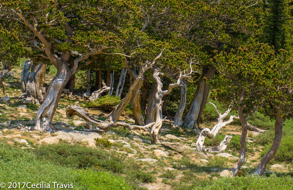
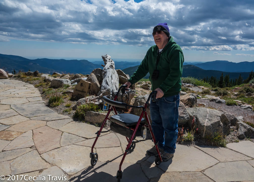
![]() A limited area is wheelchair accessible. The path through the garden is easy.
A limited area is wheelchair accessible. The path through the garden is easy.