Monongahela National Forest
Monongahela National Forest offers “scenic vistas, country roads, flowing streams and abundant plant and animal life…..It is one of the most ecologically diverse areas in the United States. Elevations range from just under 1,000 feet to 4,863 feet above sea level.”
Here is the Forest website. Phone 304-636-1800 Maps for Sale
Brochure and Map of Seneca Creek Backcountry
Lake Sherwood Area Brochure and Trails Map
Tea Creek Area Hiking Trails in Marlington Ranger District Map & Brochure
![]() Falls of Hills Creek “The first 1700 feet of trail is paved and has a wheelchair accessible path to the upper falls viewing platform.” “This popular 114 acre area contains three waterfalls – 25 feet, 45 feet, and 63 feet. The lower falls, at 63 feet is the second highest waterfall in West Virginia.”
Falls of Hills Creek “The first 1700 feet of trail is paved and has a wheelchair accessible path to the upper falls viewing platform.” “This popular 114 acre area contains three waterfalls – 25 feet, 45 feet, and 63 feet. The lower falls, at 63 feet is the second highest waterfall in West Virginia.”
![]() Whispering Spruce Trail #567 0.5 mile. “This nature trail winds through windblown rock where one can feel the sharp west wind blow. It then leads out to a point where giant boulders are scattered through an open field. Exceptional views to the east and west are seen beyond” “The wide hard graveled path has gentle slopes.”
Whispering Spruce Trail #567 0.5 mile. “This nature trail winds through windblown rock where one can feel the sharp west wind blow. It then leads out to a point where giant boulders are scattered through an open field. Exceptional views to the east and west are seen beyond” “The wide hard graveled path has gentle slopes.”
![]() Sherwood Lake Trail # 601 3.5 mile loop around Lake Sherwood. Judging from the topo map, this trail is pretty level. However, I haven’t found a difficulty rating. Call first.
Sherwood Lake Trail # 601 3.5 mile loop around Lake Sherwood. Judging from the topo map, this trail is pretty level. However, I haven’t found a difficulty rating. Call first.
Author: Cecilia
Where to hit the trail in a wheelchair
“Where to hit the trail in a wheelchair” Article in The Seattle Times by Cathy McDonald, last updated April 26, 2016. Interesting article with twelve suggestions of wheelchair accessible trails.
Seattle
City of Seattle
The application “Seattle Trails” shows you where all the official trails in Seattle are. It is a collaboration between Seattle Parks & Recreation Department, Seattle Trails Alliance and volunteer software developers. Here is a link to a page from which you can download the app.
Here is the website for Seattle Parks. 206-684-4075
Carkeek Park
“This popular park offers extraordinary views of Puget Sound and the Olympic Mountains. Explore the secrets of this northwest Seattle watershed, nine miles from downtown. Here, 220 acres of lush forest, meadows, wetlands, creeks, and beach are formed by the magic of water and time. ”
Here is Carkeek’s website. Trail Map Phone 206-684-0877 Washington Trails Association Yelp
![]() Salmon to Sound Trail, 0.3 mile “The trail gradually ascends along Mohlendorph Creek on a nice gravel path to a salmon restoration area. The trail continues beyond, and becomes narrower and less traveled. The trail ends at Venema Creek.” From HikingProject.
Salmon to Sound Trail, 0.3 mile “The trail gradually ascends along Mohlendorph Creek on a nice gravel path to a salmon restoration area. The trail continues beyond, and becomes narrower and less traveled. The trail ends at Venema Creek.” From HikingProject.
![]() Piper’s Creek Trail from Lower Meadow to Piper’s Orchard “The trail is an easy, gently graded gravel or paved trail, starting at a playground.” From Hiking Project. “Piper’s Creek and North Traverse Trail Loop is a 2.1 mile moderately trafficked loop trail…good for all skill levels” From AllTrails.
Piper’s Creek Trail from Lower Meadow to Piper’s Orchard “The trail is an easy, gently graded gravel or paved trail, starting at a playground.” From Hiking Project. “Piper’s Creek and North Traverse Trail Loop is a 2.1 mile moderately trafficked loop trail…good for all skill levels” From AllTrails.
![]() South Ridge, Hillside, Brick Road and Piper’s Creek Trail is a 1.1 mile moderately trafficked loop trail …good for all skill levels.” From AllTrails.
South Ridge, Hillside, Brick Road and Piper’s Creek Trail is a 1.1 mile moderately trafficked loop trail …good for all skill levels.” From AllTrails.
![]()
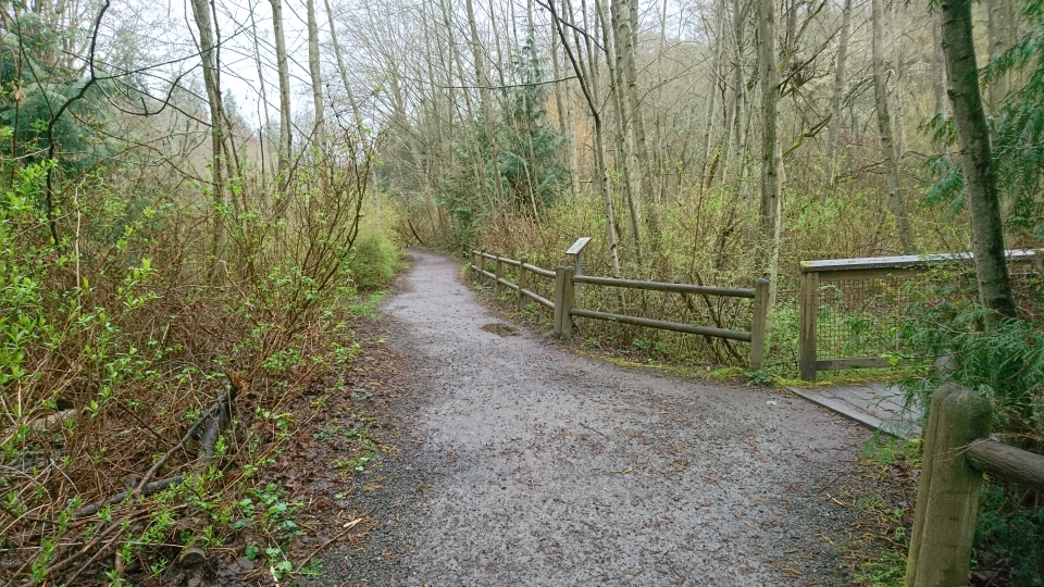
![]() ? Wetland Trail 0.2 miles The Wetland Trail is hard packed gravel with a section of wide boardwalk with railings.
? Wetland Trail 0.2 miles The Wetland Trail is hard packed gravel with a section of wide boardwalk with railings.
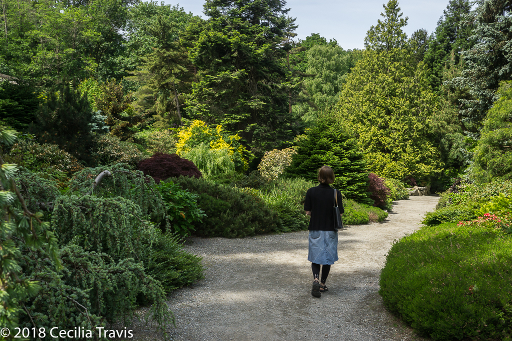
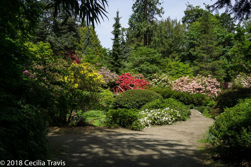
Kubota Garden
Hidden in South Seattle, Kubota Garden in south Seattle is a “…stunning 20 acre landscape that blends Japanese garden concepts with native Northwest plants. …. The Gardens are a spectacular setting of hills and valleys, interlaced with streams, waterfalls, ponds, bridges, and rock out-croppings with a rich array of plant material”
![]()
![]() Not all the trails at the Garden are accessible, but you can make your way around this beautiful place without being completely stopped by obstacles. Here is their website. Phone 206-684-4075 Map and Self-Guided tour
Not all the trails at the Garden are accessible, but you can make your way around this beautiful place without being completely stopped by obstacles. Here is their website. Phone 206-684-4075 Map and Self-Guided tour
![]() Here are AllTrails’ Best Wheelchair Friendly Trails Near Seattle
Here are AllTrails’ Best Wheelchair Friendly Trails Near Seattle
Researching trails in Seattle is proving more difficult than I would have expected. Here is an interesting article from the Seattle Times describing one man’s favorite parks with trails.
Birding
Birding For Beginners from the National Park Service. This link was sent by Jenny wise who points out that, “The beauty of this hobby is that anyone can do it, whether you live in the city or the country. You can be young or old, you can do it any time of the year, and, best of all, it’s free!”.
Tacoma
Tacoma
Tacoma Nature Center
“The Tacoma Nature Center is a 71-acre nature preserve encompassing Snake Lake and the surrounding wetlands and forest….More than two miles of soft-surfaced walking trails wander through the wetlands and forest areas.”
Here is the website for the Center. Phone 253-591-6439 Accessibility Information Trail Map
![]() First Bridge Loop Trail 0.5 mile
First Bridge Loop Trail 0.5 mile
Adriana Hess Wetland Center
Adriana Hess Wetland Center
“The Adriana Hess Wetland Park is a small park with loop trail, a shelter, benches and a viewing platform over Morrison Pond.”
Here is the Center website. Phone 253-565-9278 Address: 2917 Morrison Rd W
University Place, WA
![]() Donna Cooper Pepos Native Plant Trail ” The trail was established in 1999 as a demonstration backyard habitat area featuring native plants of the Pacific Northwest.” ADA – compliant
Donna Cooper Pepos Native Plant Trail ” The trail was established in 1999 as a demonstration backyard habitat area featuring native plants of the Pacific Northwest.” ADA – compliant
Caring4OurKids.com
Caring4OurKids.com Thank you Cyrus Dylan for the Caring4OurKids link and for the the following links: Sesame Street Autism Resources for Parents Resources for Military Families.
Okanogan-Wenatchee National Forest
Okanogan-Wenatchee National Forest
“The Okanogan-Wenatchee National Forest is a large and diverse landscape, encompassing over 4 million acres along the east slopes of the Cascade Range in Washington. “
Here is the Forest website. Interactive Visitor Map Phone 509-664-9200
“The Cascade Lookout 2015” 23 pages of information about the Forest.
Chelan Ranger District Phone 509-662-4900
![]() Ten Mile Falls Trail 1.0 mile The trail “…winds around large rocks, through aspen and Douglas fir forests to a view point where you can rest on the benches available and look out to Copper Peak and over the Copper Creek Valley. Go another 0.2 of a mile to find yourself on a viewing deck overlooking 10 Mile Falls.”
Ten Mile Falls Trail 1.0 mile The trail “…winds around large rocks, through aspen and Douglas fir forests to a view point where you can rest on the benches available and look out to Copper Peak and over the Copper Creek Valley. Go another 0.2 of a mile to find yourself on a viewing deck overlooking 10 Mile Falls.”
Methow Valley Ranger District Phone 509-996-4003 Accessible Adventures video
![]() Rainy Lake Trail 0.9 miles flat paved trail to a picnic spot. “High cliffs surround the lake, with waterfalls cascading down to the lake. In the fall, the golds and reds of the changing shrubs and trees are spectacular.”
Rainy Lake Trail 0.9 miles flat paved trail to a picnic spot. “High cliffs surround the lake, with waterfalls cascading down to the lake. In the fall, the golds and reds of the changing shrubs and trees are spectacular.”
Naches Ranger District Phone 509-653-1401 Accessible Adventures video
![]() Boulder Cave River Trail 0.75 paved loop trail
Boulder Cave River Trail 0.75 paved loop trail
![]() Clear Lake Trail 1.0 mile paved trail, fishing piers, bird watching blinds, and picnic area. “The asphalt trail takes you along the lake and through the woods to see wildflowers and if you’re quiet maybe an elk or deer.”
Clear Lake Trail 1.0 mile paved trail, fishing piers, bird watching blinds, and picnic area. “The asphalt trail takes you along the lake and through the woods to see wildflowers and if you’re quiet maybe an elk or deer.”
![]() Pleasant Valley Interpretive Trail 1.0 mile. Paved. Views of American River.
Pleasant Valley Interpretive Trail 1.0 mile. Paved. Views of American River.
![]() Mather Memorial Parkway East Portal. 0.25 mile paved trail.
Mather Memorial Parkway East Portal. 0.25 mile paved trail.
Tonasket Ranger District Phone 509-486-2186
![]() ? Big Tree Trail 1.0 mile. “Easy”. The trail “…travels 1 mile from Lost Lake Campground to the Big Tree Botanical Trailhead and Interpretive Site, then continues 0.7 mile around the loop at the Big Trail Interpretive Site where the trail highlights two 900 year old Western Larch trees with a couple of benches to take in the surrounding Western Larch and other conifer species.” “Great trail for the whole family.” The Interpretive site is accessible, I am not sure about the trail.
? Big Tree Trail 1.0 mile. “Easy”. The trail “…travels 1 mile from Lost Lake Campground to the Big Tree Botanical Trailhead and Interpretive Site, then continues 0.7 mile around the loop at the Big Trail Interpretive Site where the trail highlights two 900 year old Western Larch trees with a couple of benches to take in the surrounding Western Larch and other conifer species.” “Great trail for the whole family.” The Interpretive site is accessible, I am not sure about the trail.
Wenatchee River Ranger District Phone 509-548-2550
![]() Hidden Lake 0.75 mile “Easiest” . “The trail climbs very gently through dense forest, and provides good opportunities for nature study with small children. Once it reaches Hidden Lake, the trail becomes brushier and harder to follow as it curves along the lake’s north shore, and it ends at a lovely waterfall at the lake’s west end.”
Hidden Lake 0.75 mile “Easiest” . “The trail climbs very gently through dense forest, and provides good opportunities for nature study with small children. Once it reaches Hidden Lake, the trail becomes brushier and harder to follow as it curves along the lake’s north shore, and it ends at a lovely waterfall at the lake’s west end.”
![]() Icicle Gorge 3.6 mile interpretive loop 200 ft elevation change. “Easiest”.
Icicle Gorge 3.6 mile interpretive loop 200 ft elevation change. “Easiest”.
North Cascades National Park Complex
North Cascades National Park Complex
The North Cascades offer forested valleys with cascading waters, alpine landscapes with lakes and jagged peaks, and more than 300 glaciers. All this less than three hours from Seattle.
Here is the Complex website. Accessibility Phone 206-526-6677 Maps North Cascades and Mt. Baker Visitor Guide
Mt. Baker-Snoqualmie National Forest
“Located on the west side of the Cascades between the Canadian border and Mt. Rainier National Park, you will find glacier-covered peaks, spectacular mountain meadows and old-growth forests rich in history and outdoor opportunities.”
Here is the Forest website. Phone 425-783-6000 Links to Motor Vehicle Use Maps List of “Family friendly ADA accessible trails” Stevens Greenway: Accessible Adventures video
Baker Lake and Mt. Baker National Recreation Area
![]() Shadow of the Sentinels 0.5 mile interpretive trail through old growth forest.
Shadow of the Sentinels 0.5 mile interpretive trail through old growth forest.
![]() Sterling Munro Trail 330 feet boardwalk with view of Picket Range.
Sterling Munro Trail 330 feet boardwalk with view of Picket Range.
![]() River Loop 1.8 miles
River Loop 1.8 miles
![]() Rock Shelter Trail 0.3 mile “…to Native American campsite above Newhalem Creek, moderate grade.”
Rock Shelter Trail 0.3 mile “…to Native American campsite above Newhalem Creek, moderate grade.”
![]() Gorge Overlook Trail 0.5 mile (0.2 mile is paved), Views of Gorge Lake and Dam.
Gorge Overlook Trail 0.5 mile (0.2 mile is paved), Views of Gorge Lake and Dam.
![]() Happy Creek Forest Walk 0.3 mile boardwalk through ancient creekside forest.
Happy Creek Forest Walk 0.3 mile boardwalk through ancient creekside forest.
![]() Rainy Lake Trail 1.0 mile paved trail to lake with views of waterfall.
Rainy Lake Trail 1.0 mile paved trail to lake with views of waterfall.
![]() Washington Pass Overlook Trail 810 ft. loop trail with “…view of mountains from a high bluff. ”
Washington Pass Overlook Trail 810 ft. loop trail with “…view of mountains from a high bluff. ”
Glacier Area
![]() Boyd Creek 0.25 mile Interpretive trail focused on fish habitat.
Boyd Creek 0.25 mile Interpretive trail focused on fish habitat.
Heather Meadows Area Accessible Adventures video
![]() Picture Lake 0.5 mile interpretive loop.
Picture Lake 0.5 mile interpretive loop.
![]() Fire and Ice 0.5 mile interpretive loop.
Fire and Ice 0.5 mile interpretive loop.
![]() Artist Ridge 1.0 loop to viewpoint
Artist Ridge 1.0 loop to viewpoint
George Washington and Jefferson National Forests
George Washington and Jefferson National Forests
“The Jefferson National Forest is comprised of lands located in Virginia, West Virginia and Kentucky. The George Washington National Forest is comprised of lands located in Virginia and West Virginia.” Both of these Forests are primarily in Virginia. I am putting this one post in the pages for all three states. There are a ton of trails, many of them described as easy. You might pick an area you want to visit and call the appropriate Ranger District for advice. Here are phone numbers for the eight Ranger Districts. Supervisor’s Office Phone 540-265-5100. Links to Maps Day Hikes National Forests Foundation Here is the Forests’ website.
![]() Massanutten Storybook Trail in Lee Ranger District 0.5 miles described in Virginia Trail Guide. “…leads to a spectacular view overlooking the Blue Ridge Mountains and Shenandoah Valley. Learn from the interpretive signs of how the Massanutten Mountains were formed.”
Massanutten Storybook Trail in Lee Ranger District 0.5 miles described in Virginia Trail Guide. “…leads to a spectacular view overlooking the Blue Ridge Mountains and Shenandoah Valley. Learn from the interpretive signs of how the Massanutten Mountains were formed.”
![]()
![]() Lions Tale Accessible Trail for the Visually Impaired in Lee Ranger District 0.5 mile interpretive loop. Waymarking.com Backpacker.com “Listen to the gentle ripples of Passage Creek, feel the refreshing water running from the flume, and smell the sweet aromas of sassafras and birch.”
Lions Tale Accessible Trail for the Visually Impaired in Lee Ranger District 0.5 mile interpretive loop. Waymarking.com Backpacker.com “Listen to the gentle ripples of Passage Creek, feel the refreshing water running from the flume, and smell the sweet aromas of sassafras and birch.”
![]() Pandapas Pond Loop Trail Eastern Divide Ranger District 0.9 mile “The pond is situated in a hardwood forest. Rhododendron and flame azalea are abundant. … The trail encircles both the pond and the adjacent wetland.”
Pandapas Pond Loop Trail Eastern Divide Ranger District 0.9 mile “The pond is situated in a hardwood forest. Rhododendron and flame azalea are abundant. … The trail encircles both the pond and the adjacent wetland.”
![]() Fenwick Nature Walk Trail Eastern Divide Ranger District. 1.0 mile. “…hikers can walk through an Appalachian forest, cross Mill Creek, pass through swampy wetlands, and get a nice view of a scenic waterfall. Wildflowers are abundant during the spring.”
Fenwick Nature Walk Trail Eastern Divide Ranger District. 1.0 mile. “…hikers can walk through an Appalachian forest, cross Mill Creek, pass through swampy wetlands, and get a nice view of a scenic waterfall. Wildflowers are abundant during the spring.”
![]() Virginias Walk Trail Eastern Divide Ranger District 1.30 miles. “This 1.3 mile nature trail meanders around White Rocks Campground.”
Virginias Walk Trail Eastern Divide Ranger District 1.30 miles. “This 1.3 mile nature trail meanders around White Rocks Campground.”
![]() Rhododendron Trail James River Ranger District. 0.12 miles There is a “…wonderful view of the Rich Hole Wilderness at the end.”
Rhododendron Trail James River Ranger District. 0.12 miles There is a “…wonderful view of the Rich Hole Wilderness at the end.”
![]() Beartree Lake Trail Mount Rogers National Recreation Area 0.8 miles paved and gravel-surfaced trail which encircles Beartree Lake.
Beartree Lake Trail Mount Rogers National Recreation Area 0.8 miles paved and gravel-surfaced trail which encircles Beartree Lake.
![]() Jackson River Fishing Trail Warm Springs Ranger District 0.85 miles. Primarily used for fishing access to the Jackson River, the trail follows an old roadbed and has scenic views of the river.
Jackson River Fishing Trail Warm Springs Ranger District 0.85 miles. Primarily used for fishing access to the Jackson River, the trail follows an old roadbed and has scenic views of the river.
![]() Hidden Valley West Trail in Warm Springs Ranger District 1.08 miles. Follows the Jackson River downstream.
Hidden Valley West Trail in Warm Springs Ranger District 1.08 miles. Follows the Jackson River downstream.