Equinox Preservation Trust
“Consisting of 914 acres on the slopes of Mt Equinox
in Manchester, the Trust “is the home to rare plants & varied wildlife, diversified woodlands, marble ledges, springs, wetlands and a pond. From the upper slopes, there are exceptional views.”
Here is the Trust website. Phone 802-366-1400 Trails Trail Map
![]() Pond Loop 0.75 mile “Easy loop through beautiful hardwoods around Equinox Pond on a level woods road.”
Pond Loop 0.75 mile “Easy loop through beautiful hardwoods around Equinox Pond on a level woods road.”
Author: Cecilia
Eshqua Bog Natural Area
Eshqua Bog Natural Area
“Eshqua Bog is a botanical wonderland of cold-climate holdovers—small pockets of bog and a two acre fen—from the post-glacial era 10,000 years ago. This preserve contains a diverse array of bog and fen plants: labrador tea, cotton grass, pitcher plants, showy lady’s slippers, larches and buckbean. “
Here is the Area website. Nature Conservancy Phone 802-229-4425 or 802-884-8165
![]() Handicap Accessible Boardwalk 460′
Handicap Accessible Boardwalk 460′
Green Mountain & Finger Lakes National Forests
Green Mountain & Finger Lakes National Forests
“The 16,212-acre Finger Lakes National Forest lies on a ridge between Seneca and Cayuga Lakes in the beautiful Finger Lakes region of New York State. ”
“The Green Mountain National Forest (GMNF) encompasses more than 400,000 acres in southwestern and central Vermont.”
The Green Mountain and Finger Lakes National Forests’ Supervisor’s Office is located in Rutland, VT. The Green Mountain National Forest in Vermont has Ranger Stations in Manchester and Rochester, VT. The Finger Lakes National Forest in New York has a Ranger Station in Hector, NY.
Here is the Forests’ website. Supervisor’s Phone 802-747-6700. Manchester Ranger Station phone 802-362-2307. Rochester Ranger Station phone 802-767-4261. Hector Ranger Station phone 607-546-4470.
![]() Thundering Falls Trail Guide 900′ of boardwalk in the Appalachian Trail leading to the sixth tallest waterfall in Vermont. In Green Mountain National Forest near Killington.
Thundering Falls Trail Guide 900′ of boardwalk in the Appalachian Trail leading to the sixth tallest waterfall in Vermont. In Green Mountain National Forest near Killington.
![]() Robert Frost Interpretive Trail The first 0.3 miles across a beaver pond boardwalk to the South Branch of the Middlebury River is accessible for wheelchairs. The 1.2 mile loop trail is an “easy walk” . Trail guide and map.
Robert Frost Interpretive Trail The first 0.3 miles across a beaver pond boardwalk to the South Branch of the Middlebury River is accessible for wheelchairs. The 1.2 mile loop trail is an “easy walk” . Trail guide and map.
![]() ? South Slope Trail 0.75 mile “The trail passes through hardwood and conifer stands and crosses a small stream. It is a primitive trail with plank boardwalk over wet areas. ” It is classified as easy. Call the Hector Ranger Station to be sure.
? South Slope Trail 0.75 mile “The trail passes through hardwood and conifer stands and crosses a small stream. It is a primitive trail with plank boardwalk over wet areas. ” It is classified as easy. Call the Hector Ranger Station to be sure.
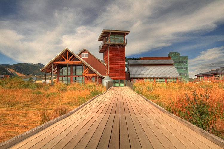
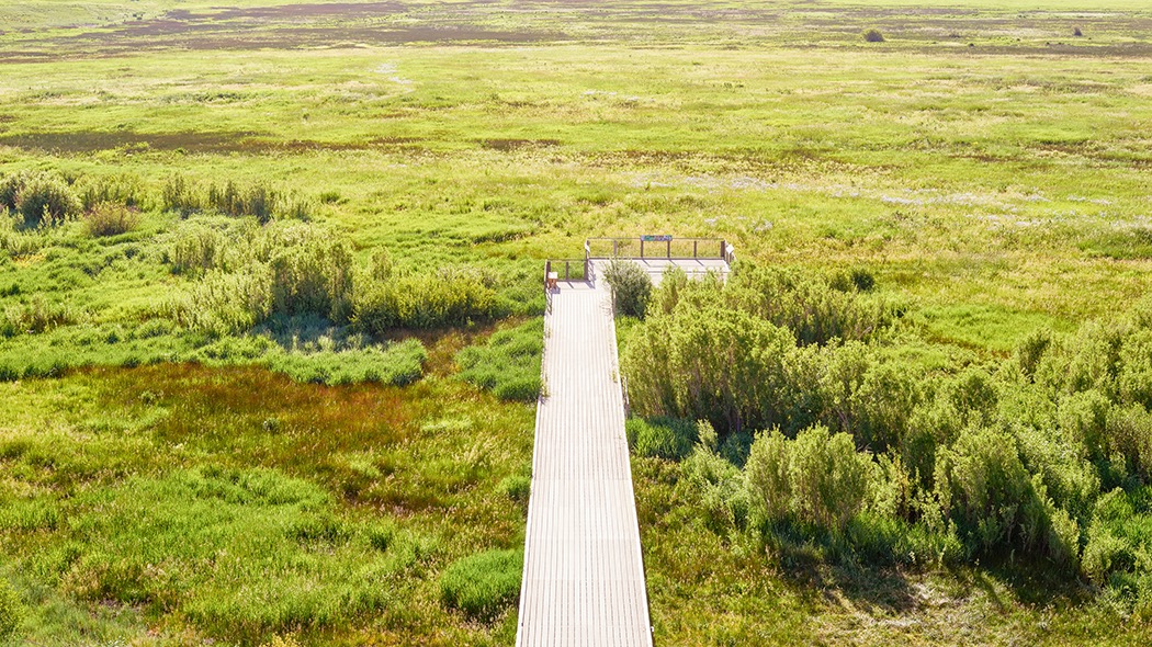
Swaner EcoCenter
Swaner EcoCenter
“The Swaner Preserve and EcoCenter is a 1,200 acre nature Preserve ….with interactive exhibits about the surrounding environment. … Visit the EcoCenter to learn more about our wetland ecosystem and the 10 miles of trails to explore!”
Here is the Center website. Utah State University 435-649-1767 Preserve and Trails
![]() Leslie, who answered my inquiry (and provided the photos) writes, “The EcoCenter and the pier going out onto the preserve are wheelchair accessible. However, in the winter the pier is covered with snow for snowshoeing. I would say summer and fall would be the best times for elderly and people with wheelchairs to visit.”
Leslie, who answered my inquiry (and provided the photos) writes, “The EcoCenter and the pier going out onto the preserve are wheelchair accessible. However, in the winter the pier is covered with snow for snowshoeing. I would say summer and fall would be the best times for elderly and people with wheelchairs to visit.”
Camel’s Hump State Park
Camel’s Hump State Park
“Camel’s Hump State Park does not have an entrance or office. It spans five towns and can be accessed from numerous undeveloped parking lots and trails.”
Here is the Park website. Phone 802-879-6565 Map
![]() Camel’s Hump View Trail This loop is 0.8 mile long and ADA complaint. It is “wide and flat, and has three viewing spots to the summit of Camel’s Hump – it’s perfect for small kids and elders.”
Camel’s Hump View Trail This loop is 0.8 mile long and ADA complaint. It is “wide and flat, and has three viewing spots to the summit of Camel’s Hump – it’s perfect for small kids and elders.”
Jamaica State Park
Jamaica State Park
“Jamaica State Park is located on a bend of the West River about one-half mile from the center of the town of Jamaica.”
Here is the Park website. Phone 802-874-4600 Trails Guide
![]() West River Trail The 2 miles from the park entrance to Cobb Bridge are universally-accessible. The whole rail-trail is 16 miles. The trail meanders along the West River, following the old bed of the West River Railroad.
West River Trail The 2 miles from the park entrance to Cobb Bridge are universally-accessible. The whole rail-trail is 16 miles. The trail meanders along the West River, following the old bed of the West River Railroad.
Smugglers’ Notch State Park
Smugglers’ Notch State Park
The Park contains a 3.5-mile long scenic highway “though a steep and winding pass filled with beautiful vistas and recreational opportunities….Visitors can stroll along the wetlands boardwalk near the Barnes Camp Visitor Center or begin a hike on the Long Trail. The Smugglers’ Notch Picnic Area, set by a beautiful stream, is further up the road. I do not see any easy trail in this park, so have taken it out of the category list
Here is the Park website. Phone 802-253-4014 Map and Guide
-Vermont State Parks
Vermont State Parks
Here is the website for information on the over 30 Vermont State Parks open until mid-October. Searchable map of Vermont State Parks. You can select amenities such as “trails” or “universal access” to narrow the search. There are links to each state park.
Vermont State Parks Hiking Trails This site lists the trails and gives maps for each state park. Length, estimated hiking time, trail difficulty and whether or not a trail is considered “kid-friendly” is given for each trail. Here is the same information on a printable PDF.
Nature Trails in Vermont State Parks Descriptions of six short interpretive nature trails. Accessibility is not addressed.
Accessibility in Vermont Sate Parks
Robert N. Hasenyager Great Salt Lake Nature Center
Robert N. Hasenyager Great Salt Lake Nature Reserve
The Reserve is located along the southeast shore of the Great Salt Lake, adjacent to the Utah Division of Wildlife Resources’ Farmington Bay Waterfowl Management Area (WMA). The new (2019) George S. and Dolores Doré Eccles Wildlife Education Center at Farmington Bay is on the Reserve. The Center and trails provide “…. a gateway to the remarkable Great Salt Lake wetlands. ”
Here is the Eccles Center website. Phone 801-451-5536.
![]() Farmington Creek Trail 1.5 miles ADA compliant. The “trail loops through the wetlands of Farmington Bay with several side trails. The trail features a 1700-foot-long boardwalk with a bridge over Farmington Creek, a long bridge across a large pond, and a winding boardwalk through a delightful marsh filled with birds of many kinds.”
Farmington Creek Trail 1.5 miles ADA compliant. The “trail loops through the wetlands of Farmington Bay with several side trails. The trail features a 1700-foot-long boardwalk with a bridge over Farmington Creek, a long bridge across a large pond, and a winding boardwalk through a delightful marsh filled with birds of many kinds.”
Bear River Migratory Bird Refuge
Bear River Migratory Bird Refuge
“…Bear River MBR contains nearly 80,000 acres of marsh, open water, uplands, and alkali mudflats.” “Birds come to the Refuge by the millions to eat and rest during migration, and many other species stay to breed, nest and raise their young across the Refuge wetlands.”
Here is the Refuge website. Phone 435-723-5887 Hunting & Fishing brochure with map facebook page
![]() Marsh Meander trail 1.5 mile unpaved trail through the wetland habitat just outside the center.
Marsh Meander trail 1.5 mile unpaved trail through the wetland habitat just outside the center.
![]() Wetland Walk is partially paved, and may be at least partly accessible but the website does not say so. AllTrails calls it a 0.6 mile loop.
Wetland Walk is partially paved, and may be at least partly accessible but the website does not say so. AllTrails calls it a 0.6 mile loop.