Ogden Nature Center
This 152-acre nature preserve and education center is open to the public year-round offering a wide variety of activities. “The center has limited paved paths. The rest of the center is leveled dirt trails.” Call to learn if any of these trails will accommodate your wheelchair.
Here is the Center’s website. Phone 801-621-7595 Map Virtual Tour
![]() There are 1.5 miles of “easy walking trails and paths. Most are dirt trails, and a few are paved…”
There are 1.5 miles of “easy walking trails and paths. Most are dirt trails, and a few are paved…”
Author: Cecilia
Snow Canyon State Park
Snow Canyon State Park
“Explore the trails and dunes of beautiful Snow Canyon ….. Camp in the peaceful campground surrounded by ancient lava flows and red Navajo sandstone.”
Here is the Park website. Brochure & Trail Map Overview Map Phone 435-628-2255
![]() Whiptail Trail 6 miles. “Level with some slopes. Accessible to people with disabilities. Tucked along the canyon bottom, this paved trail is suitable for walking, jogging, and biking.”
Whiptail Trail 6 miles. “Level with some slopes. Accessible to people with disabilities. Tucked along the canyon bottom, this paved trail is suitable for walking, jogging, and biking.”
![]() Jenny’s Canyon 0.5 mile, Johnson Canyon 2 miles, Pioneer Names 0.5 mile, West Canyon Road 8 miles, and Sand Dunes 0.5 mile are trails rated as easy with some slopes and/or steps. Check with the Visitor Center to see if some of them would work for you.
Jenny’s Canyon 0.5 mile, Johnson Canyon 2 miles, Pioneer Names 0.5 mile, West Canyon Road 8 miles, and Sand Dunes 0.5 mile are trails rated as easy with some slopes and/or steps. Check with the Visitor Center to see if some of them would work for you.
Kodachrome Basin State Park
Kodachrome Basin State Park
“67 monolithic stone spires, called sedimentary pipes, accentuate multihued sandstone layers that reveal 180 million years of geologic time. The color and beauty found here prompted a National Geographic Society expedition to name the area Kodachrome…”
Here is the Park website. Phone 435-679-8562 Brochure & Trails Map
![]() Grand Parade Trail 1.5 miles is easy, but check first to be sure it is suitable for you.
Grand Parade Trail 1.5 miles is easy, but check first to be sure it is suitable for you.
![]() Nature Trail 0.5 miles hard surface interpretive trail.
Nature Trail 0.5 miles hard surface interpretive trail.
Historic Union Pacific Rail Trail
Historic Union Pacific Rail Trail
“Weaving its way from Park City to Echo Reservoir, this 28-mile, non-motorized trail provides a close-up view of area wildlife and wildflowers.”
Here is the Trail website. Phone 435-649-6839 Map
![]() This rail trail is 28 miles following interstate 80 from Park City to Echo Reservoir. It is mostly gravel, but there are 3 miles north from Park City and a 0.5 section in Wanship that are asphalt and suitable for wheelchairs. TrailLink’s description
This rail trail is 28 miles following interstate 80 from Park City to Echo Reservoir. It is mostly gravel, but there are 3 miles north from Park City and a 0.5 section in Wanship that are asphalt and suitable for wheelchairs. TrailLink’s description
Fremont Indian State Park
Fremont Indian State Park
Discover artifacts, petroglyphs, and pictographs left behind by the Fremont Indians. This museum preserves treasures from the largest known Fremont Indian village site. “Hike on paths that lead you up close to Rock art panels left by the Fremont people. “
Here is the Park website. Phone 4335-527-4631 Brochure
![]() Parade of Rock Art 0.4 miles paved interpretive trail
Parade of Rock Art 0.4 miles paved interpretive trail
Dead Horse Point State Park
Dead Horse Point State Park
“From the prominence of Dead Horse Point, 2,000 feet above a gooseneck in the Colorado River, an ever-changing landscape unfurls. Immense vertical cliffs meet with canyons carved by ice, water, and wind creating a visual masterpiece.”
Here is the Park website. Visitor Center phone 435-259-2614 Map Trail Map
Brochure Hiking
![]() Overlook Trail 200′ one way. “…a short paved pathway leads to breathtaking views of the Colorado River and adjacent canyon country some 2,000 feet below.”
Overlook Trail 200′ one way. “…a short paved pathway leads to breathtaking views of the Colorado River and adjacent canyon country some 2,000 feet below.”
![]() Visitor Center Trail 1/8 mile round trip. “The paved path just outside the Visitor Center offers great views of the basin to the east, the La Sal Mountains and Chimney Rock.” There are eight trail-side exhibits.
Visitor Center Trail 1/8 mile round trip. “The paved path just outside the Visitor Center offers great views of the basin to the east, the La Sal Mountains and Chimney Rock.” There are eight trail-side exhibits.
![]() The East Rim Trail System 1.5-2 miles “Aside from a short hill a quarter mile from the visitor center, this trail is predominately flat. ”
The East Rim Trail System 1.5-2 miles “Aside from a short hill a quarter mile from the visitor center, this trail is predominately flat. ”
![]() The Colorado River Overlook 1 mile.
The Colorado River Overlook 1 mile.
Antelope Island State Park
Antelope Island State Park
The park offers “spectacular views of lake and island scenery.” There are sandy beaches and you can “…take a dip in the lake’s salty waters or step back in time with a visit to the Historic Fielding Garr Ranch. Antelope Island is home to free-ranging bison, mule deer, bighorn sheep, pronghorn (antelope), and many other desert animals. Millions of birds congregate along the shores surrounding the island…”
Here is the Park website. Trails Map Brochure Utah Travel Secrets trail guide
Headquarters phone 801-649-5742, Visitor Center Phone 801-725-9263
![]() Lakeside Trail 2.8 miles one way. “An easy hike” that “follows a nicely maintained gravel path” with elevation gain of only 69′.
Lakeside Trail 2.8 miles one way. “An easy hike” that “follows a nicely maintained gravel path” with elevation gain of only 69′.
![]() Mountain View Trail is 11.38 miles one way and can be accessed via four parking areas. It follows the east shore of the island. “Wetlands and wildlife are abundant on the trail.”
Mountain View Trail is 11.38 miles one way and can be accessed via four parking areas. It follows the east shore of the island. “Wetlands and wildlife are abundant on the trail.”
10 Stroller Friendly Trails in Utah
10 Stroller Friendly Trails in Utah by “Utah’s Adventure Family” is part of their very helpful website for families. You should also check out their page on Nature Trails.
12 Wheelchair Accessible Trails in Utah
12 Wheelchair Accessible Trails in Utah is a page on wanderookie.com, an excellent source of information on “Utah hikes and outdoor recreation for rookie adventurers”.
Dixie National Forest
Dixie National Forest
The almost 2,000,000 acres of Dixie National Forest stretch for about 170 miles across southern Utah. The forest includes Red Canyon and Hell’s Backbone Bridge. There are many opportunities for “hiking, fishing, and viewing outstanding scenery.”
Here is the Forest website. Phone 801-466-6411 Maps
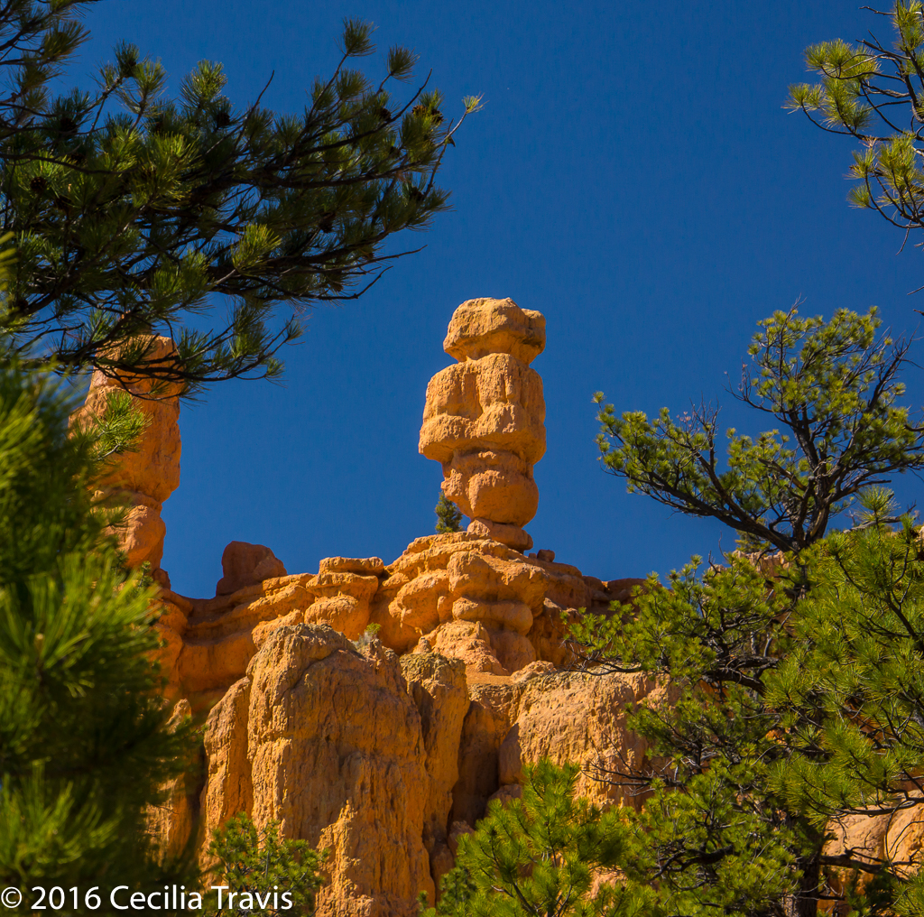
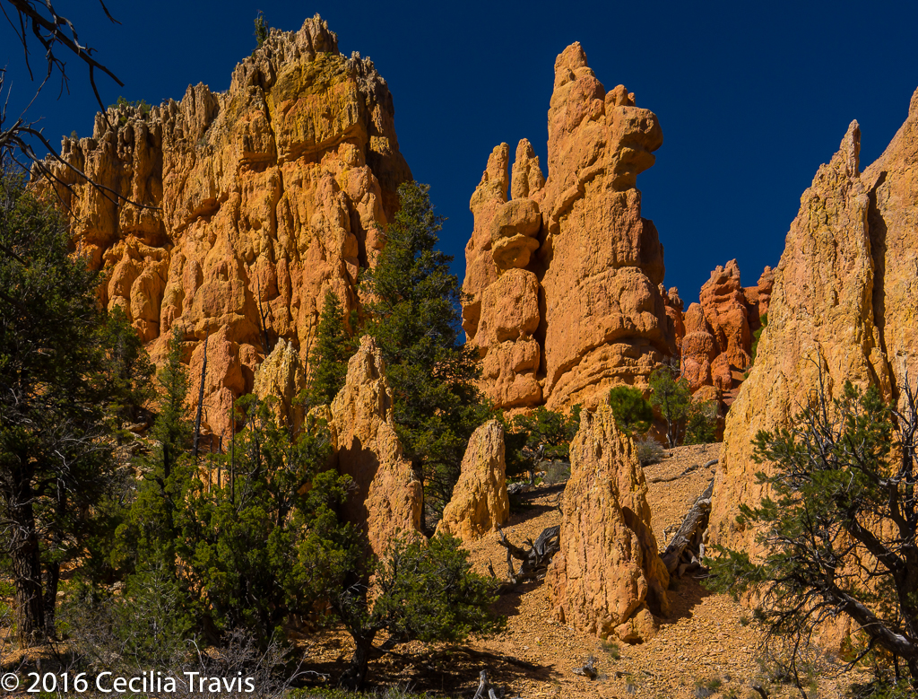
Red Canyon Powell Ranger District Visitor Center Phone 435-676-2676 Trails Map and Descriptions The map omits the easy Hoodoo Trail. Red Canyon is a lovely place near Bryce National Park, but without the crowds.
![]() Hoodoo Trail #3011 0.3 mile “Walk under the hoodoos, through sagebrush, pinyon, and juniper trees.”
Hoodoo Trail #3011 0.3 mile “Walk under the hoodoos, through sagebrush, pinyon, and juniper trees.”
![]() Pink Ledges Interpretive Trail 0.4 miles This trail is a bit more difficult than the Hoodoo, so you may just want to go for part of it and then turn around if you don’t like the slope.
Pink Ledges Interpretive Trail 0.4 miles This trail is a bit more difficult than the Hoodoo, so you may just want to go for part of it and then turn around if you don’t like the slope.