Big Oaks Recreation Area
Big Oaks Recreation Area is a summer day-use area on Hartwell Lake, a man-made 56,000 acre lake bordering Georgia and SC on the Savannah, Tukgaloo and Seneca Rivers. Description on Oh Ranger! Map Phone (706) 856-0300 Hartwell Lake Visitor Center phone 888-893-0678 Here is their website. Reviewed on tripadvisor
![]() Hartwell Dam Walking Trail on the Georgia side 1.37 miles one-way “….follows the shoreline of Hartwell Lake from Big Oaks up to the concrete portion of the dam on the Georgia side.”
Hartwell Dam Walking Trail on the Georgia side 1.37 miles one-way “….follows the shoreline of Hartwell Lake from Big Oaks up to the concrete portion of the dam on the Georgia side.”
![]() Hartwell Dam Walking Trail on the South Carolina side 0.75 mile one-way. “….follows the shoreline up to the concrete portion of Hartwell Dam on the South Carolina side. For a shorter walk, you can access this trail from the South Carolina Recreation Area, located approximately midway between the South Carolina Overlook and the GA/SC border.”
Hartwell Dam Walking Trail on the South Carolina side 0.75 mile one-way. “….follows the shoreline up to the concrete portion of Hartwell Dam on the South Carolina side. For a shorter walk, you can access this trail from the South Carolina Recreation Area, located approximately midway between the South Carolina Overlook and the GA/SC border.”
Author: Cecilia
Poinsett State Park
Poinsett State Park
Poinsett State Park is in the “mountains of the midlands,” a mixed ecosystem with a high degree of biodiversity.
Here is the Park website. Phone: 803-494-8177 Map Trail Map Trail and Topo Map Brochure
![]() ?? Scout Trail 1.9 miles connects to the Wateree Passage of the Palmetto Trail. The first part (maybe 0.5 mile) , along the Palmetto Trail, appears to be pretty flat. See description under Manchester State Forest. The Park describes all its trails as “moderate”, but tripleblaze.com describes the Scout Trail as “easy” and sctrails.net says the trail is “moderately difficult”.
?? Scout Trail 1.9 miles connects to the Wateree Passage of the Palmetto Trail. The first part (maybe 0.5 mile) , along the Palmetto Trail, appears to be pretty flat. See description under Manchester State Forest. The Park describes all its trails as “moderate”, but tripleblaze.com describes the Scout Trail as “easy” and sctrails.net says the trail is “moderately difficult”.
Manchester State Forest
Manchester State Forest
Manchester State Forest is “approximately 28,675 acres of mixed pine and hardwood species native to the midlands of South Carolina. Soil type is light sand, interspersed with swamps and bays.”
Trails Map Phone 803-494-8196 Here is their website.
![]() ? Wateree Passage of the Palmetto Trail The first 2.25 miles of this 7.2 mile trail sound doable, but better call first. Manager J Map You can start from Poinsett State Park on the Scout Nature Trail. Read this review from tripleblaze.com for information and a caution about two other starting points. From Carolina Hiking
? Wateree Passage of the Palmetto Trail The first 2.25 miles of this 7.2 mile trail sound doable, but better call first. Manager J Map You can start from Poinsett State Park on the Scout Nature Trail. Read this review from tripleblaze.com for information and a caution about two other starting points. From Carolina Hiking
Harbison State Forest
Harbison State Forest
Bounded along its northeastern edge by the Broad River, Harbison Environmental Education Forest encompasses 2,137 acres of forestland only nine miles from downtown Columbia.
Here is the Forest website. Phone 803-896-8897 Trail Guide and Map Photographs
![]() Learning Trail 0.9 mile is a short trail around the Education Center.
Learning Trail 0.9 mile is a short trail around the Education Center.
Savannah National Wildlife Refuge
Savannah National Wildlife Refuge
Savannah National Wildlife Refuge has “…29,452 acres of freshwater marshes, tidal rivers and creeks, and bottomland hardwoods. About half the refuge is bottomland, composed primarily of cypress, gum, and maple species. Access to these areas is by boat only. ” Phone 843-784-2468 Here is their website. Reviewed on Trip Advisor Maps Trail Map
Thanks to Ranger Amy Ochoa for the following information:
![]() The only wheelchair accessible trail is at the Visitor Center is an 800 ft. long paved trail “that runs from one side to the other. ” However there is “an outstanding 4.25 mile wildlife drive that visitors can drive around and get … the same wildlife viewing opportunities as walking on the trails…..pretty much anywhere along it there’s room for a car to pull to the side, stop, even get out and look, while still allowing room for a vehicle to pass by.”
The only wheelchair accessible trail is at the Visitor Center is an 800 ft. long paved trail “that runs from one side to the other. ” However there is “an outstanding 4.25 mile wildlife drive that visitors can drive around and get … the same wildlife viewing opportunities as walking on the trails…..pretty much anywhere along it there’s room for a car to pull to the side, stop, even get out and look, while still allowing room for a vehicle to pass by.”
![]() ? “The trails are all the same surface; grass covered, earthen dikes. They’re not always mowed, depending on the availability of heavy equipment operators to run the large mower, so things like fire ants and snakes could be present and not easily seen. Like any earthen path, they would all be subject to holes, bumps, etc. that could trip up someone not sure-footed.”
? “The trails are all the same surface; grass covered, earthen dikes. They’re not always mowed, depending on the availability of heavy equipment operators to run the large mower, so things like fire ants and snakes could be present and not easily seen. Like any earthen path, they would all be subject to holes, bumps, etc. that could trip up someone not sure-footed.”
Bucks County Audubon Society at Honey Hollow
Bucks County Audubon Society at Honey Hollow
Honey Hollow has 1″10-acres with 6 miles of trails, meadows, forests, ponds, wetlands, and streams. Visit our Healing Garden, Explore the Honey Hollow Creek and Pond, and Discover our Agricultural Fields!”
Here is their website. Phone 215-297-5880 Trail Map
Diane Smith, Educational Director, writes, “We have one trail that I consider accessible (although maybe not fully ADA compliant), our Visitor Center is accessible and some trails are very easy.” ![]() “On the …. map, trail L, Bird Blind or Lavender trail is accessible. “
“On the …. map, trail L, Bird Blind or Lavender trail is accessible. “
![]() “All of the trails in the bluebird meadow (M, pink) are easy, as are some of the approaches to the pond (G, green). None of the trails are paved but the easy/accessible ones are smooth, grassy and not steep.”
“All of the trails in the bluebird meadow (M, pink) are easy, as are some of the approaches to the pond (G, green). None of the trails are paved but the easy/accessible ones are smooth, grassy and not steep.”
Carolina Sandhills National Wildlife Refuge
Carolina Sandhills National Wildlife Refuge
“Carolina Sandhills National Wildlife Refuge is comprised of 47,850 acres…” “Numerous small creeks and tributaries, along with thirty man-made lakes and ponds and 1,200 acres of fields, support a diversity of habitats for wildlife.”
Phone 843-335-8401 Here is the Refuge website. Map of Walking Tours and Public Use General Map Brochure
Manager Allyne Askins writes that , “All of our trails have been around for decades and as such constructed before the ADA law. Our trails range in length from 1/4 mile to 3.5 miles, but all have slight hills, soft footing, tree roots and other debris. We do have many elderly visitors who use the trails, but none with mobility issues.”
![]() Descriptions of the maintained trails are on the Visitor Activities page of the refuge website. The trails include the one mile loop Woodland Pond Nature Trail, 0.25 mile Longleaf Pine Trail, 3.5 mile Tate’s Trail, the 0.6 mile Pine Barrens Gentian Trail, and the 0.25 mile Tripod Trail that leads to a photo blind on Martin’s Lake.
Descriptions of the maintained trails are on the Visitor Activities page of the refuge website. The trails include the one mile loop Woodland Pond Nature Trail, 0.25 mile Longleaf Pine Trail, 3.5 mile Tate’s Trail, the 0.6 mile Pine Barrens Gentian Trail, and the 0.25 mile Tripod Trail that leads to a photo blind on Martin’s Lake.
Edisto State Park
Edisto State Park
“Rich in Native American history, Edisto Beach on Edisto Island is one of four oceanfront state parks in South Carolina.”
Here is their website. Phone 843-869-2156 Map & Trails Brochure
From the staff at Edisto Beach: “All of our trails, except for the Forest Loop Trail, were designed to be ADA-Accessible. Our trails were built with a nice, hard packed sand that makes for easy walking or movement in a wheelchair. The trails are also very flat and feature only minimal gains in elevation. They are also very wide and easy to navigate due to the placement of trail markers at each intersection. The bridges over Scott Creek were also designed to accommodate the passage of wheelchairs, so you should have no problems with them.”
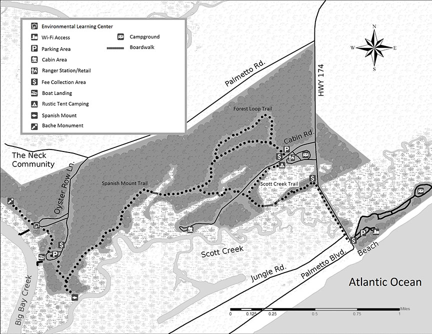
![]() Spanish Mount Trail 1.7 miles “One of the earliest Native American shell mound sites in South Carolina can be found at the western terminus of the Spanish Mount Trail.”
Spanish Mount Trail 1.7 miles “One of the earliest Native American shell mound sites in South Carolina can be found at the western terminus of the Spanish Mount Trail.”
![]() Scott Creek Trails 0.7 miles “..takes one through the maritime forest offering views of the marsh from three boardwalks. ”
Scott Creek Trails 0.7 miles “..takes one through the maritime forest offering views of the marsh from three boardwalks. ”
![]() Big Bay Trail 0.4 miles “This short trail will take you from the Education Center through the boat ramp parking area to the Spanish Mount. ”
Big Bay Trail 0.4 miles “This short trail will take you from the Education Center through the boat ramp parking area to the Spanish Mount. ”
![]() Campground Trail 0.3 miles …”will take you from the Education Center through the boat ramp parking area to the Spanish Mount.”
Campground Trail 0.3 miles …”will take you from the Education Center through the boat ramp parking area to the Spanish Mount.”
![]() Edisto Bike Trail 0.4 miles “runs along the paved causeway leading to the beach area of the park and to the Town of Edisto. From the intersection of the Scott Creek Trail and the Edisto Bike Trail, it is an easy 0.4 miles to the beach.”
Edisto Bike Trail 0.4 miles “runs along the paved causeway leading to the beach area of the park and to the Town of Edisto. From the intersection of the Scott Creek Trail and the Edisto Bike Trail, it is an easy 0.4 miles to the beach.”
Silver Bluff Audubon Center & Sanctuary
Audubon Center & Sanctuary at Silver Bluff
“Audubon’s Silver Bluff Sanctuary is a 3,400-acre woodland overlooking the Savannah River. Here you’ll find extensive pine forests and bottomland hardwood forests; 22 miles of horse and walking trails; 50 acres of lakes and ponds; 100 acres of grassland; and all manner of birds and wildlife.”
Here is their website. Trail map Phone: 803-471-0291
Thank you to Director Paul Koehler for the following information:
![]() Nuthatch Trail 3/4 mile loop. “our ¾-mile trail is 8 feet wide and perfectly flat. At times it has some fallen pine cones and sticks on it, but those are negotiable by nearly everyone. It has a bench halfway along for a walker to sit and rest.”
Nuthatch Trail 3/4 mile loop. “our ¾-mile trail is 8 feet wide and perfectly flat. At times it has some fallen pine cones and sticks on it, but those are negotiable by nearly everyone. It has a bench halfway along for a walker to sit and rest.”
![]() Tanager Loop Trail 2 miles “The two-mile trail is similar, but has two 100-foot stretches with a slight elevation change. It takes about an hour to walk if one walks at a steady pace. It has several benches along the way. The length of this trail, of course, would prohibit some people from attempting it. ”
Tanager Loop Trail 2 miles “The two-mile trail is similar, but has two 100-foot stretches with a slight elevation change. It takes about an hour to walk if one walks at a steady pace. It has several benches along the way. The length of this trail, of course, would prohibit some people from attempting it. ”
“I have seen a knobby-wheeled motorized wheelchair and baby strollers use both trails. Access to our visitor center, the restrooms, and water fountain are all ADA compliant.”
Allegheny County
Allegheny County Parks
Thanks to Braden Meiter for the following information and suggestions about accessibility in the parks. Here is their website. 412-350-7275
Nextpittsburgh Article by Michele Fetting
North Park Brochure & Map Paved Trails Blazed Trails-Central 724-935-1766 or 724-935-1971
![]() Lake Loop: 5 miles, mostly flat, paved.
Lake Loop: 5 miles, mostly flat, paved.
![]() Swimming pool (south ridge) loops: Paved loops on shoulder of road. Very wide shoulder. As little as .5 miles to about 1.5 miles. Figure eight loops.
Swimming pool (south ridge) loops: Paved loops on shoulder of road. Very wide shoulder. As little as .5 miles to about 1.5 miles. Figure eight loops.
![]() Swimming pool (south ridge) loops: Map Blazed trails leaving from Pie Traynor Field. Gravel or wide natural surface, low elevation change. Suggested Route: Head south from Pie Traynor parking lot onto trail with white with red dot blaze. Follow to intersection with South ridge road. Make right turn onto white blaze trail. Follow to Pie Traynor parking lot.
Swimming pool (south ridge) loops: Map Blazed trails leaving from Pie Traynor Field. Gravel or wide natural surface, low elevation change. Suggested Route: Head south from Pie Traynor parking lot onto trail with white with red dot blaze. Follow to intersection with South ridge road. Make right turn onto white blaze trail. Follow to Pie Traynor parking lot.
[ Latodami Nature Center trails Phone 724-935-2170
![]() Nature Access Trail map 0.4 mile Braille trail]
Nature Access Trail map 0.4 mile Braille trail]
Hartwood Acres Park Map Basic Trail Map Detailed Trail Map 412-767-9200
![]() Mansion parking lot: Wide, mostly flat, natural surface. Cross street from parking lot. Follow trail #10 until it meets an unmarked intersection, bear in the sidebar. Trail intersects with purple trail (trail 12), go right. Stay straight through intersections until back at trail beginning.
Mansion parking lot: Wide, mostly flat, natural surface. Cross street from parking lot. Follow trail #10 until it meets an unmarked intersection, bear in the sidebar. Trail intersects with purple trail (trail 12), go right. Stay straight through intersections until back at trail beginning.
Deer Lakes Park Map 724-265-3520
![]() Paved Pond Trails: Paved, mostly flat. Loops starting from Splash park or Veterans Shelter Parking lots. Distance variable.
Paved Pond Trails: Paved, mostly flat. Loops starting from Splash park or Veterans Shelter Parking lots. Distance variable.
Harrison Hills Park Map Map of Blazed Trails 724-295-3570
![]() Paved loop at CottonTail Drive Playground: Flat, paved, 0.5 mile .
Paved loop at CottonTail Drive Playground: Flat, paved, 0.5 mile .
![]() Environmental Learning Center Loop: Mostly flat, wide, natural surface trail, approximately 1 mile. Park at ELC. Walk north on gravel service road. Turn right onto purple trail through meadow. At intersection with green trail, turn right and follow back to service road. Turn left back to ELC parking lot.
Environmental Learning Center Loop: Mostly flat, wide, natural surface trail, approximately 1 mile. Park at ELC. Walk north on gravel service road. Turn right onto purple trail through meadow. At intersection with green trail, turn right and follow back to service road. Turn left back to ELC parking lot.
South Park north half of Map south half of Map Trails 412-835-4809 or 412-835-4810, or 412-835-5710
![]() Corrigan Drive: flat, paved. Couple different parking locations, not a loop; out and back. 2 Miles.
Corrigan Drive: flat, paved. Couple different parking locations, not a loop; out and back. 2 Miles.
![]() Maple Springs Road Exercise Loop: flat, rock/gravel, some paved spots. 1.75 Miles.
Maple Springs Road Exercise Loop: flat, rock/gravel, some paved spots. 1.75 Miles.
Round Hill Park Map Trails- Not Blazed 412-384-4701
![]() The Farm: Everything around the farm is paved and loops all around to the different animals ( .5 miles).
The Farm: Everything around the farm is paved and loops all around to the different animals ( .5 miles).
![]() The trails here are not blazed, would be difficult to explain. Some trails, however, are flat around the farm , as they are also accessed by tractors/other farm equipment.
The trails here are not blazed, would be difficult to explain. Some trails, however, are flat around the farm , as they are also accessed by tractors/other farm equipment.
White Oak Park Map 412-678-3774 or 412-350-2455
![]() Sylvan Drive: It is a paved road that comes to a dead end, main park road, which most of the shelters are on. There is rarely heavy traffic and safe for most park visitors. Very popular for walking.
Sylvan Drive: It is a paved road that comes to a dead end, main park road, which most of the shelters are on. There is rarely heavy traffic and safe for most park visitors. Very popular for walking.
Settlers Cabin Park Map
![]() Panhandle Connector Trail: Leaves from the old park office on Greer Rd. Trail is completely paved and is 0.67 mile long – eventually it will connect to the Panhandle Trail once property is acquired.
Panhandle Connector Trail: Leaves from the old park office on Greer Rd. Trail is completely paved and is 0.67 mile long – eventually it will connect to the Panhandle Trail once property is acquired.
![]() Panhandle rail trail is nearby: http://www.railstotrails.us/pa_panhandle_trail.htm
Panhandle rail trail is nearby: http://www.railstotrails.us/pa_panhandle_trail.htm
Boyce Park Map Trails Map 724-327-0338 or 724-327-8798 Visitor Center 724-733-4618
![]() Centerview Drive: Paved, mostly flat, some hills. Variable distances depending on parking.
Centerview Drive: Paved, mostly flat, some hills. Variable distances depending on parking.
Wide paved berm with light traffic. ![]() Trail from Silver Beaver: Old road, paved but is not a loop.
Trail from Silver Beaver: Old road, paved but is not a loop.