Ohio State Nature Preserves Accessible Nature Preserves Call the Ohio Department of Natural Resources 614-265-6565 for more information.
There are 136 State nature Preserves and natural areas in Ohio., “Most…contain small parking lots and a trail system.” “Restrooms, picnic facilities and areas for active recreation are generally not available.” Some are within State Parks and are described under that heading.
![]() Blackhand Gorge Brochure Photographs on this website show a paved path and it is listed as having an ADA trail. This is probably the four mile bike trail, part of which is currently (10/2015) under repair.
Blackhand Gorge Brochure Photographs on this website show a paved path and it is listed as having an ADA trail. This is probably the four mile bike trail, part of which is currently (10/2015) under repair.
![]() Cooperrider-Kent Bog Brochure The 0.5 mile boardwalk leads you through this “living relect from the Ice Age.”
Cooperrider-Kent Bog Brochure The 0.5 mile boardwalk leads you through this “living relect from the Ice Age.”
Author: Cecilia
Cross Ranch State Park
Cross Ranch State Park
“Situated along the west bank of the Missouri River, the 589-acre Cross Ranch State Park and adjacent 6,000-acre Cross Ranch Nature Preserve are one of the few areas in North Dakota to offer a true primitive outdoor experience.”
Here is the Park website. Map Phone 701-794-3731
![]() Matah “River” Trail: “This 2.9-mile trail begins at the Visitor Center and loops around the park’s main use areas. Along the river, interpretive signs describe the history, wildlife and geology of the area. The Matah Trail Self Guided Loop is the innermost loop covering 1.4 miles and takes up to an hour and a half to hike. Self-guided brochures are available at the trailhead or Visitor Center.” Thank you, Stephanie Heklowski for the following: “Our Matah Trail is wide and an easy walking trail, it remains pretty flat the whole time. For wheelchair accessibility it is probably not the greatest. We have a lot of elderly people that do come out here to walk the trail but they usually just do part of it. As a whole the trail would take about an hour to walk at a decent pace.”
Matah “River” Trail: “This 2.9-mile trail begins at the Visitor Center and loops around the park’s main use areas. Along the river, interpretive signs describe the history, wildlife and geology of the area. The Matah Trail Self Guided Loop is the innermost loop covering 1.4 miles and takes up to an hour and a half to hike. Self-guided brochures are available at the trailhead or Visitor Center.” Thank you, Stephanie Heklowski for the following: “Our Matah Trail is wide and an easy walking trail, it remains pretty flat the whole time. For wheelchair accessibility it is probably not the greatest. We have a lot of elderly people that do come out here to walk the trail but they usually just do part of it. As a whole the trail would take about an hour to walk at a decent pace.”
– North Dakota State Parks
North Dakota State Parks require either a $5 daily entry fee per vehicle or the $25 North Dakota State Parks annual pass.
Lake Metigoshe State Park
Lake Metigoshe State Park
“…..the lake is noted for its northern pike, walleye and perch. The rolling hills, aspen forests and small lakes attract nature and photography lovers to the area….” ” The Old Oak Trail, a National Recreation Trail, is found within the park boundaries. “
Here is the Park website. Map Trails For information call 701-263-4651.
![]() ? Thanks to Amy Schimetz for the following: [see the Map] “We have multi-use trails (red) that are in most places 12+ feet wide, whereas the Old Oak/Hemerick Trails are much narrower, only a few feet wide, comparable to a glorified game trail. The multi-use trails are grass-covered and can be quite uneven, having dips and low-lying areas which would be hazards. The Old Oak and the Hemerick Trails looks is a dirt path having dips, exposed tree roots in places, areas where trail is close to a cliff/drop-off, etc. All of our trails here at the park have portions that, in our opinion, would be flat and gently sloping but further down the trail is steeper. There is no one trail that we would suggest over the other due to the slopes and uneven ground.”
? Thanks to Amy Schimetz for the following: [see the Map] “We have multi-use trails (red) that are in most places 12+ feet wide, whereas the Old Oak/Hemerick Trails are much narrower, only a few feet wide, comparable to a glorified game trail. The multi-use trails are grass-covered and can be quite uneven, having dips and low-lying areas which would be hazards. The Old Oak and the Hemerick Trails looks is a dirt path having dips, exposed tree roots in places, areas where trail is close to a cliff/drop-off, etc. All of our trails here at the park have portions that, in our opinion, would be flat and gently sloping but further down the trail is steeper. There is no one trail that we would suggest over the other due to the slopes and uneven ground.”
“We are currently researching what it would take to make the Old Oak Trail, or a portion of it, handicap accessible. “
Lewis and Clark State Park
Lewis and Clark State Park
Lewis and Clark State Park is on one of the upper bays of Lake Sakakawea. “The park features miles of shoreline with picturesque views of towering buttes and rolling hills, that provide a rugged backdrop for the park. “Here is the Park website. Map Phone 701-859-3071
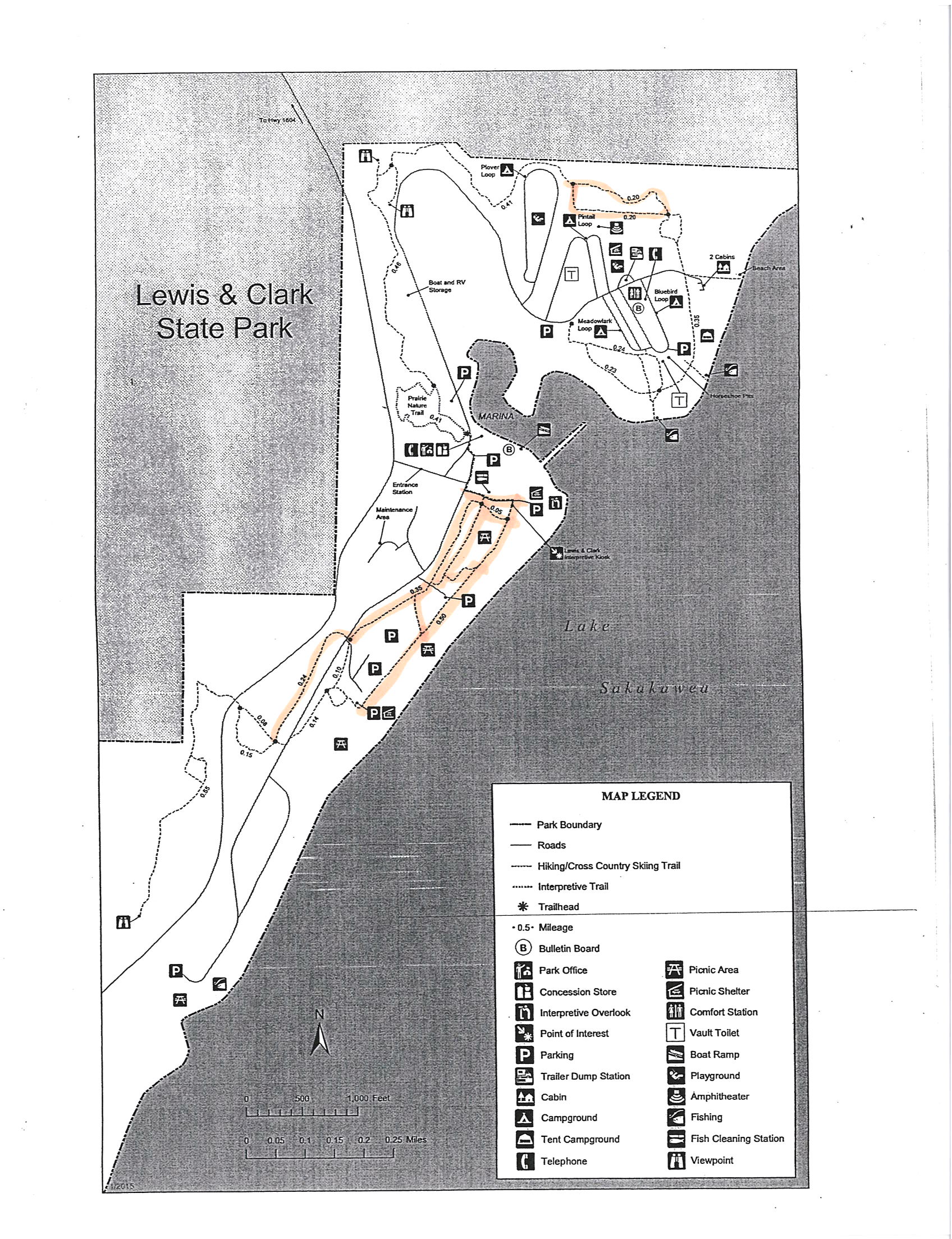
![]() Thanks to Assistant Park Manager Katie Ogden for this description: “We do have several trails along our shoreline that are wider and that are more level. I would recommend utilizing the trails in the west end of the park along the shoreline or the loop [northeast] east of the parks campgrounds.” …….”I have included a [ Map of Recommended Trails ] that has several highlighted options that I feel would accommodate the needs of your website and viewers. The trails in the west end of the park are truly beautiful and give you a wonderful panoramic of the Badlands and of Lake Sakakawea”. ………” We have a wide range of wildlife that can be seen from Pheasant, Grouse, Hungarian Partridge, Wild Turkey, Mule Deer, Whitetail Deer, Raccoon, Coyote, and various Song Birds.”
Thanks to Assistant Park Manager Katie Ogden for this description: “We do have several trails along our shoreline that are wider and that are more level. I would recommend utilizing the trails in the west end of the park along the shoreline or the loop [northeast] east of the parks campgrounds.” …….”I have included a [ Map of Recommended Trails ] that has several highlighted options that I feel would accommodate the needs of your website and viewers. The trails in the west end of the park are truly beautiful and give you a wonderful panoramic of the Badlands and of Lake Sakakawea”. ………” We have a wide range of wildlife that can be seen from Pheasant, Grouse, Hungarian Partridge, Wild Turkey, Mule Deer, Whitetail Deer, Raccoon, Coyote, and various Song Birds.”
Audubon National Wildlife Refuge
Audubon National Wildlife Refuge
The refuge is 14,735 acres of “native prairie, planted grasslands, and wetlands”……”managed to provide food,water, shetler, and space to meet the need of waterfowl and other migratory birds, threatened and endangered species, and resident wildlife. ”
Map Here is the Refuge website. Phone 701-442-5474 .
![]() Prairie Nature Trail is accessible to wheelchair users with some help. Thanks to Visitor Services Manager Jackie Jacobson for this description: “The prairie nature trail is approximately 1 mile in length and has a gravel surface. ……we have found that the gravel does not stay real well packed along the entire length of the trail. We have had students who use wheelchairs and they have needed to have a person with them to help push the wheelchair, as the wheels do not always stay on top of the gravel….especially if we have had rain. The cross slope is very minimal on the trail and is considered to be accessible. A person who is walking slowly, or using a cane or walker could navigate through this trail. It is a loop, but people are invited to hike as much as they are comfortable with, and then turn around and come back to the visitor center. “
Prairie Nature Trail is accessible to wheelchair users with some help. Thanks to Visitor Services Manager Jackie Jacobson for this description: “The prairie nature trail is approximately 1 mile in length and has a gravel surface. ……we have found that the gravel does not stay real well packed along the entire length of the trail. We have had students who use wheelchairs and they have needed to have a person with them to help push the wheelchair, as the wheels do not always stay on top of the gravel….especially if we have had rain. The cross slope is very minimal on the trail and is considered to be accessible. A person who is walking slowly, or using a cane or walker could navigate through this trail. It is a loop, but people are invited to hike as much as they are comfortable with, and then turn around and come back to the visitor center. “
– North Dakota State Trail Guide
Theodore Roosevelt National Park
Theodore Roosevelt National Park
The three units of Theodore Roosevelt National Park cover 70,446 acres of badlands and floodplain. The Little Missouri River flows through all three units of the park contributing to the diversity of habitat, plants, and animals. Periodic flooding has helped to establish cottonwood forests. Flat grasslands on the floodplains provide forage for the park’s numerous grazing mammals, including bison, deer, horses, and elk.
Here is the Park website. Hiking Guide and Trail Map Accessibility Phone 701-623-4466
![]() Skyline Vista Overlook is a 0.1 mile paved, flat nature trail on Johnson’s Plateau.
Skyline Vista Overlook is a 0.1 mile paved, flat nature trail on Johnson’s Plateau.
![]() Little Mo Nature Trail has a 0.7 mile inner loop which is paved and an 1.1 mile outer loop which is unpaved. Trail brochures are available at the trailhead.
Little Mo Nature Trail has a 0.7 mile inner loop which is paved and an 1.1 mile outer loop which is unpaved. Trail brochures are available at the trailhead.
![]() Boicourt Overlook is a 0.2 mile trail with a “slight grade”. Hard surface.
Boicourt Overlook is a 0.2 mile trail with a “slight grade”. Hard surface.
![]() Wind Canyon Trail 0.4 mile along a canyon to a view of the Little Missouri River.
Wind Canyon Trail 0.4 mile along a canyon to a view of the Little Missouri River.
Mount Mitchell State Park
Mount Mitchell State Park Map (828) 675-4611 Trails described on the WNCoutdoors.info website.
![]() Commissary Trail 1 mile. “Provides spectacular views of Mount Mitchell and the mountains below. Passes through grassy fields on Bearwallow and Grassy Knob Ridges; also Spruce-Fir forests.”
Commissary Trail 1 mile. “Provides spectacular views of Mount Mitchell and the mountains below. Passes through grassy fields on Bearwallow and Grassy Knob Ridges; also Spruce-Fir forests.”
![]() Summit Trail 0.1 mile A paved path from the summit parking area to the observation deck at the top.
Summit Trail 0.1 mile A paved path from the summit parking area to the observation deck at the top.
![]() The State Parks’ website says there is a trail for the visually impaired at Mount Mitchell, but I haven’t found any information about it. Try calling the park.
The State Parks’ website says there is a trail for the visually impaired at Mount Mitchell, but I haven’t found any information about it. Try calling the park.
-North Carolina State Parks
North Carolina State Parks – this is a page from which you can look for accessible facilities in the state parks.