![]() Trail Finder This wonderful site lets you plug in your parameters to come up with names and information on trails in Vermont and the Upper Valley of New Hampshire. I put in “easy” and “wheelchair accessible” and brought up 25 trails in Vermont! “Easy” and “nature and interpretive” brought up 24 trails, two in New Hampshire.
Trail Finder This wonderful site lets you plug in your parameters to come up with names and information on trails in Vermont and the Upper Valley of New Hampshire. I put in “easy” and “wheelchair accessible” and brought up 25 trails in Vermont! “Easy” and “nature and interpretive” brought up 24 trails, two in New Hampshire.
Author: Cecilia
Palouse Falls State Park
Palouse Falls State Park
“The Palouse River runs through a narrow cataract and drops 200 feet to a churning bowl. From there, the current moves swiftly, through a winding gorge of columnar basalt, to its southern end at the mighty Snake River.”
Here is the Park website. There is no phone service at the park, and staff and volunteer hosts are not always available. Brochure Phone for information 509- 646-9218
![]() There is a 0.1 mile ADA trail to a view of the falls. Thank you, JP Bruce for the suggestion and the photo.
There is a 0.1 mile ADA trail to a view of the falls. Thank you, JP Bruce for the suggestion and the photo.
Fort Williams Park
Town of Cape Elizabeth
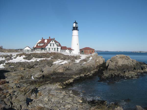
Portland Headlight and Fort Williams Park
“Cape Elizabeth is the home of Portland Head Light. Situated along the spectacular shores of Fort Williams Park, at 1000 Shore Road, the popular landmark is owned and managed by the Town of Cape Elizabeth, Maine. The Park is open year round from sunrise to sunset.”
Here is the Park website. Phone 207-799-2661.
![]() The Cliff Walk to the Portland Head Light is an “easily followed crushed stone path that winds along the scenic cliffs and historic remains of Fort Williams. A highlight is the Portland Head Light located right on the path.” From Main Trail Finder.
The Cliff Walk to the Portland Head Light is an “easily followed crushed stone path that winds along the scenic cliffs and historic remains of Fort Williams. A highlight is the Portland Head Light located right on the path.” From Main Trail Finder.
Thank you, Eric Rathbon, for letting me know about this trail and for the photo.
Kealia Pond NWR
Kealia Pond National Wildlife Refuge
Kealia Pond NWR is on Maui, on Ma’alaea Bay. It is a wetland transition from urban development and agriculture fields. Endangered Hawaiian waterbirds are protected here and are joined by migratory birds in winter. Information about the Refuge’s wildlife and habitat. Map Here is their website. Phone 808-875-1582 to find out about accessibility of these trails.
![]() Kanuimanu Ponds Trail 0.8 mile From Oh Ranger , “This trail provides the best wildlife viewing and photography access at the refuge. Visitors hike along the perimeter of refuge ponds to view one of the largest concentrations of endangered water birds, migratory waterfowl and shorebirds in Hawaii. ”
Kanuimanu Ponds Trail 0.8 mile From Oh Ranger , “This trail provides the best wildlife viewing and photography access at the refuge. Visitors hike along the perimeter of refuge ponds to view one of the largest concentrations of endangered water birds, migratory waterfowl and shorebirds in Hawaii. ”
![]() Kealia Coastal Boardwalk is a “2,200-foot boardwalk and kiosk with self-guided interpretive exhibits…”
Kealia Coastal Boardwalk is a “2,200-foot boardwalk and kiosk with self-guided interpretive exhibits…”
Dale Bumpers White River National Wildlife Refuge
Dale Bumpers White River National Wildlife Refuge
The Dale Bumpers White River National Wildlife Refuge has a paved loop handicap accessible trail and other short trails which sound as though they may be easy. Call 870-282-8200 to learn more.
The refuge is one of the most important areas for wintering waterfowl in North America and is also home to the only population of native black bear in the State of Arkansas. It lies mostly in the floodplain of the White River, near where it meets the Mississippi River. The refuge is one of the largest remaining bottomland hardwood forests in the Mississippi River Valley, with fertile forests and some three hundred lakes, interlaced with streams, sloughs, and bayous. The result is a haven for a myriad of native wildlife and migratory birds. Here is the park website and a description of trails.
![]() Upland Trail is a paved one mile loop with interpretive panels and benches.
Upland Trail is a paved one mile loop with interpretive panels and benches.
Know more about Dale Bumpers White River National Wildlife Refuge?
Have you visited this location and know of more accessible or easy trails? Is any of the information given here incorrect? If so, please contact me using the form to the left and let me know what should be changed or added so I can update this post.
Hike New England
Hike New England This marvelous, searchable website lists hikes in Maine, Vermont, New Hampshire, Massachusetts, Connecticut, and Rhode Island with information about difficulty, length, elevation gain, and features. There are maps and photos for many of the hikes. Using their Hike Finder, I did a search for Easy trails, 5 miles or less and came up with 51 trails! Be aware that Easy for them, might not be easy enough for you. Once you come up with a page for a sanctuary, park, forest, whatever, it would be wise to call for trail conditions.
White Mountain National Forest
White Mountain National Forest
“The White Mountain National Forest in eastern New Hampshire and western Maine ranges from mountainous hardwood forests to majestic alpine peaks.”
There are nine trails described in this brochure on accessible trails and here is a brochure on accessible water bodies.
Here is the Forest website. Phone 603-536-6100. Visitor center phone 603-536-3665
Pemigewasset Ranger District 603-536-6100
![]() Forest Discovery Trail Guide Book 1.53 miles long in two loops. “There are breathtaking views, and opportunities to see some wildlife. ”
Forest Discovery Trail Guide Book 1.53 miles long in two loops. “There are breathtaking views, and opportunities to see some wildlife. ”
![]() Lincoln Woods Trail ” The trail crosses a suspension bridge over the East Branch of the Pemigewasset River, then follows an abandoned railroad grade for 2.8 miles along the west side of the river.”
Lincoln Woods Trail ” The trail crosses a suspension bridge over the East Branch of the Pemigewasset River, then follows an abandoned railroad grade for 2.8 miles along the west side of the river.”
![]() Livermore Road a former logging road which is mostly level and shaded by trees.
Livermore Road a former logging road which is mostly level and shaded by trees.
![]() Lower Ammonoosuc River Trail 0.2 mile trail to a view of the lower falls.
Lower Ammonoosuc River Trail 0.2 mile trail to a view of the lower falls.
Saco Ranger District phone 603-447-5448
![]() Rail N’ River Trail 0.5 mile “…fairly flat, shady loop trail takes you out to the Swift River…” This description came from a now expired website by Eric Rathbun.
Rail N’ River Trail 0.5 mile “…fairly flat, shady loop trail takes you out to the Swift River…” This description came from a now expired website by Eric Rathbun.
![]() Rocky Gorge Scenic Area There are two possible trails here. From the parking area to Falls Ponds is 1,300′, but a short stretch sounds a little steep. An alternate trail follows the river for about 1,000′.
Rocky Gorge Scenic Area There are two possible trails here. From the parking area to Falls Ponds is 1,300′, but a short stretch sounds a little steep. An alternate trail follows the river for about 1,000′.
![]() Diana’s Baths “The Baths are located 0.8 miles from the trailhead at the parking area.”
Diana’s Baths “The Baths are located 0.8 miles from the trailhead at the parking area.”
![]() Sabbaday Falls “…..0.4 mile trail leads to a picturesque series of cascades in a narrow flume. The gravel trail is wheelchair accessible, but is steep in places (6 to 25% grades) with frequent level spots.”
Sabbaday Falls “…..0.4 mile trail leads to a picturesque series of cascades in a narrow flume. The gravel trail is wheelchair accessible, but is steep in places (6 to 25% grades) with frequent level spots.”
Photography From Your Car
Photographer JP Bruce, who has mobility limitations, has written a book, Photography From Your Car: Or Very Near.
Crotched Mountain
Crotched Mountain
“With over 1,200 acres of permanently protected forest, open fields of wild blueberry and heather, and mysterious wetlands, Crotched Mountain [near Greenfield] is a place of unusual beauty. …… Crotched Mountain’s accessible trails provide a place where everyone – people with disabilities, seniors and families with children – are welcomed and able to experience nature up close. ”
Here is their website. Call 603-547-3311 for information. Trail Guide and map.
![]() There are 2 miles of accessible trails Trails at Crotched Mountain
There are 2 miles of accessible trails Trails at Crotched Mountain
Rhododendron State Park
Rhododendron State Park
The park’s focus is the 16-acre grove of Rhododendron Maximum, the largest rhododendron grove in northern New England. “From early spring to the first frost, wildflowers bloom throughout the 2,723-acre park. The last blooms in the fall are complemented by the forest’s brilliant foliage.”
Here is the Park website. Map Brochure
![]() “A 0.6 mile-long universally accessible trail encircles the grove allowing visitors to observe, close up, the fragrant clusters of pink blossoms as they burst into bloom in mid-July.”
“A 0.6 mile-long universally accessible trail encircles the grove allowing visitors to observe, close up, the fragrant clusters of pink blossoms as they burst into bloom in mid-July.”