Fontainebleau State Park
Fontainebleau State Park is a 2,800-acre park is located on the shore of Lake Pontchartrain. There is a sandy beach and a rail/trail…There are over 400 different species of birds and animals living in and around Fontainebleau. Bordered on three sides by water–Lake Pontchartrain, Bayou Cane and Bayou Castine–and characterized by a convergence of diverse ecosystems, the park has a multitude of habitats for birds.
The Louisiana State Parks Facilities chart shows a visitor center and ADA wheelchair accessible trail(s).
Here is the Park website. Phone 985-624-4443 Map
![]() Nature Trail 1.25 miles interpretive. If only one of these two trails is ADA compliant, I think it is probably this one.
Nature Trail 1.25 miles interpretive. If only one of these two trails is ADA compliant, I think it is probably this one.
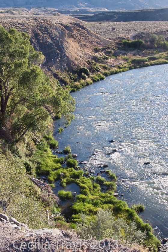
![]() ? Hiking Trail 4.8 miles You might want to check with the visitor center to be sure this is an easy trail.
? Hiking Trail 4.8 miles You might want to check with the visitor center to be sure this is an easy trail.
Author: Cecilia
Tickfaw State Park
Tickfaw State Park
“Strolling through four ecosystems on over a mile of boardwalks through Tickfaw State Park, visitors can experience the sights and sounds of a cypress/tupelo swamp, a bottomland hardwood forest, a mixed pine/hardwood forest and the Tickfaw River.”
Here is the Park website. Phone 888-981-2020 or 225-294-5020 Map
![]() The Louisiana State Parks Facilities chart shows ADA wheelchair accessible walking trails at Tickfaw.
The Louisiana State Parks Facilities chart shows ADA wheelchair accessible walking trails at Tickfaw.
LA State Arboretum State Preservation Area
LA State Arboretum State Preservation Area
“The Arboretum is more than 600 acres of natural growth, embellished with additional plantings of species that are indigenous to the state. ….The landscape ranges from nearly flat along the Walker Branch of Lake Chicot to relatively steep slopes along the terrace ridges. …. almost every type of Louisiana vegetation, except coastal marsh and prairie, is represented on the site.”
Picnic grounds and camping facilities are available at nearby Chicot State Park.
Here is the Area website. Phone (888)677-6100 or 337-363-6289 Trail map
![]() The LA Parks facilities chart show that there are ADA wheelchair accessible walking trails in the park.
The LA Parks facilities chart show that there are ADA wheelchair accessible walking trails in the park.
Casper
Casper
” The River Trail, the spine of our community system, travels 11 miles along the North Platte River corridor. In addition to being the primary east/west non-motorized transportation corridor, the River Trail is suitable for a range of activities for people of all ages and abilities….Casper’s community trail system also includes the Casper Rail Trail …” Platte River Trails.
![]() River Trail Map “The Platte River Trail connects 10 local parks that feature picnic tables and some covered shelter areas.” Phone 307-577-1206
River Trail Map “The Platte River Trail connects 10 local parks that feature picnic tables and some covered shelter areas.” Phone 307-577-1206
Cody
Cody
“The City of Cody has more than 20 developed parks and nearly 9 miles of developed trails and pathways. Three developed pathway systems were designed to meet the needs of many users. If you enjoy rollerblading with a lakeside view or jogging along the scenic Shoshone River, your recreational needs will be met in Cody.”
Dept. of Parks and Pathways. Phone (307) 587-0400
Beck Lake Park
![]()
![]() “Beck Lake Park has more than two miles of asphalt trails encircling two large reservoirs, offering spectacular views of Cody and beyond. Other features include a developed Braille Trail, Cody Lions Club picnic shelters, handicapped accessible fishing piers.” Phone 307-586-4112
“Beck Lake Park has more than two miles of asphalt trails encircling two large reservoirs, offering spectacular views of Cody and beyond. Other features include a developed Braille Trail, Cody Lions Club picnic shelters, handicapped accessible fishing piers.” Phone 307-586-4112
![]() Shoshone Riverway Trail 1.3-mile trail follows along the scenic Shoshone River and is accessible from two points within the community. The recycled asphalt base allows for walking, jogging, and biking. Phone 307-586-4112
Shoshone Riverway Trail 1.3-mile trail follows along the scenic Shoshone River and is accessible from two points within the community. The recycled asphalt base allows for walking, jogging, and biking. Phone 307-586-4112
Access Ability Wisconsin™
Access Ability Wisconsin™ is a non-profit organization dedicated to facilitating and providing the means for individuals with mobility challenges to access and enjoy Wisconsin ‘s natural resources.
Pagosa Springs
Pagosa Springs
The Pagosa Springs Town Park and Centennial Park lie along the San Juan River. They are connected by the San Juan Riverwalk.
Here is the town website. Phone is 970-264-4151. Thank you to Becky Herman for letting me know about this riverside trail where she likes to go birding when its free of snow.
![]() San Juan Riverwalk 1.9 miles described on AllTrails.
San Juan Riverwalk 1.9 miles described on AllTrails.
City & County of Milwaukee
City & County of Milwaukee
Milwaukee has a ton of trails, many of them paved.
Milwaukee County Parks has the 43-mile “Forked Aster Trail System” connecting 28 parks. The trails pass through diverse woodlands, wetlands, and prairies in the Park System’s 9,200 acres of natural areas. Call Parks to learn more about which parks have trails suitable for your abilities.
Milwaukee County Parks Phone 414-257-7275 Links to Maps of County Parks
Accessibility in Milwaukee Parks. TrailLink lists 47 walking trails around Milwaukee!
There are accessible piers at Holler Park and Scout Lake Park, or you can fish along the seawall at Veterans Park.
![]() Wehr Nature Center Phone 414-425-8550 Map Another Map 220 acres and 5 miles of trails going through forest, prairie, savanna, and wetland. There is an accessible boardwalk to a deck on the lake.
Wehr Nature Center Phone 414-425-8550 Map Another Map 220 acres and 5 miles of trails going through forest, prairie, savanna, and wetland. There is an accessible boardwalk to a deck on the lake.
![]() Oak Leaf Trail 125 miles. Although largely an urban trail, quite a bit of it runs along the shores of Lake Michigan. The trail system is mostly smooth asphalt. Map
Oak Leaf Trail 125 miles. Although largely an urban trail, quite a bit of it runs along the shores of Lake Michigan. The trail system is mostly smooth asphalt. Map
![]() Bugline Trail 15.6 mile asphalt rail/trail
Bugline Trail 15.6 mile asphalt rail/trail
![]() ? Cudahy Nature Preserve
? Cudahy Nature Preserve
Cudahy Nature Preserve is an “outstanding example of the hardwood forests that once covered most of Milwaukee County” Phone 414-257-6521 Trails
![]() Greenfield Park 1.2 mile “paved loop featuring a lake with opportunities to see wildlife along your walk.”
Greenfield Park 1.2 mile “paved loop featuring a lake with opportunities to see wildlife along your walk.”
![]() ? Bender Park Beach on Lake Michigan shoreline. Description in TripAdvisor. Phone 414-762-1550 Map
? Bender Park Beach on Lake Michigan shoreline. Description in TripAdvisor. Phone 414-762-1550 Map
![]() Boerner Botanical Gardens
Boerner Botanical Gardens
“Ramps throughout the Botanical Gardens take you to colorful and fragrant displays in 12 garden spaces.
Phone 414-525-5600 Map
Wheelchair Wandering
Wheelchair Wandering
“Wheelchair Wandering” by Jeanine Schmitz is a great source of ideas from her outdoor adventures in a wheelchair. She lives near Seattle so many of her described trails are in the Northwest, including British Columbia and Alberta. Her blog is informative and fun to read.