Nevada City

Nevada City
Nevada City, California backs onto the Tahoe National Forest and has many accessible trails within or near the town.  The city website lists a number of trails you can access walking from downtown or via a short drive.  “The good news with all of these outings is the accessibility to the outdoors and proximity to in-town coffee shops, restaurants, wineries, pubs, art galleries and theaters.”  Here is the city website’s listing of area trails.   By clicking on the hiking boot by this map of Nevada County you can see all the trails in the county.  Here is another map showing the location of trails in the Nevada City and Grass Valley area.

Wheelchair AccessibleHirschman Trail  “The eastern 0.4 mile of trail is constructed to ADA standards, providing barrier-free access to Hirschman’s Pond.”  Map
HikerwithcaneCascade Canal Trail  4.5 miles one way.  “…an almost level walk along a peaceful canal through a forest with many Douglas firs and dogwoods.  At 3200′ elevation, it is a bit higher and cooler than many local trails.”  Map
Wheelchair AccessibleIndependence Trail – East and West.  See Bear Yuba Trust  Map
Cathedral Gorge State Park

Cathedral Gorge State Park
“Cathedral Gorge State Park is located in a long, narrow valley in southeastern Nevada, where erosion has carved dramatic and unique patterns in the soft bentonite clay.”

Here is the Park website.   Phone 775-728-4460  Trail map   
Wheelchair AccessibleNature Loop is one mile.  The Park Service states that “Bridge may impede wheelchair use.” You might want to call them for clarification.
HikerwithcaneJuniper Draw is 4 miles in a dry wash, described as easy with negligible altitude gain.
HikerwithcaneEagle View Overlook is a 1/2 mile path with negligible altitude gain. “Overlook of entire Gorge; nature loop at beginning has interpretive signs.”

Nebraska National Forest and Grasslands

Nebraska National Forests and Grassland    
P
ine Ridge National Recreation Area
“The Nebraska National Forest encompasses nearly 1.1 million acres of land in central and northwest Nebraska and in central and southwest South Dakota. The administrative units comprising the Nebraska are the Nebraska and Samuel R. McKelvie National Forests and the Buffalo Gap, Oglala, and Fort Pierre National Grasslands.”
Here’s the website for the Nebraska National Forests and Grassland.  The Pine Ridge National Recreation Area lies within it.  Pine Ridge is described here by SummitPost.org and on Oh Ranger.com.
For questions about trails in the Oglala National Grassland or Nebraska National Forest you can call Mike Watts at 308-432-0390 or the Chadron Office at 308-432-0300.
HikerwithcaneHere are some suggestions from Mike Watts.  Use discretion – remember that one person’s Easy is another’s Challenging.
“……..a few sections of trail and areas to hike that are scenic and relatively easy.
1. Soldier Creek Campground, South Fork Trailhead. The Trooper Trail follows the drainage of the South Fork of Soldier Creek for about 3 miles before it heads up into the hills. This part of the trail is relatively level with rolling terrain. There are a few short steep sections and a few small creek crossings. This section of the trail is in the Soldier Creek Wilderness.
2. Soldier Creek Campground, Middle Fork Trailhead. A two track unmarked trail follows the Middle Fork of Soldier Creek drainage. The two track enters the Wilderness after 1 ½ miles and continues for about another 1 ½ miles before it heads up into the hills. This is level to gently rolling. A variation of this is to take a two track trail that forks in the sidebar up the North Fork of Soldier Creek about ¼ mile from the campground. This 2 track is relatively level for about 1 mile before it intersects the Boots and Saddle Trail.
3. From Chadron State Park take the paved loop road to the top of the loop. Take the gravel road to the Black Hills Overlook. After approximately 2 miles the road dead ends at a parking lot on Forest Service land. From the parking lot take the Black Hills Overlook Trail. The trail follows ridges through an old burn area and is level to gently rolling with a few short steep pitches. After about 1 mile the trail begins to get steeper as it drops in elevation just before the trail forks. The right hand fork will take you down to the Chadron State Park Campground. The other fork will take you to down to the Outrider Trailhead on Forest Service. Both of these forks are approximately 1 mile.
4. Approximately 5 miles south of Chadron on Highway 385 turn east on King Canyon Road. Continue east across a cattle guard onto Forest Service Road 733. After about ½ mile on Road 733 a high clearance or 4WD vehicle is recommended. Approximately 1 ½ miles from the start of Road 733 at the top of a hill you can access a section of the Pine Ridge Trail that follows a ridge through an old burn area. Parking is available next to the road. Follow the trail to the north for about 1 ½ miles. This section of trail is mostly level to gently rolling. There are a couple of short steep pitches. After about a mile when you reach a fork in the trail take the left fork out to an overlook.”

Barr Lake State Park

Barr Lake State Park
Barr Lake State Park surrounds a 1900 acre reservoir ringed with Cottonwoods, marshes and aquatic plants.  It is a favorite with the birding community.
You can ride their “Eagle Express” (like a golf cart seating 14) for a naturalist guided tour.  It is available in warm weather on weekends.  Call 303-659-6005 for information.
Here is the Park website.   Phone 303-655-1495 or 303-659-6005  Trails   Brochure and Map
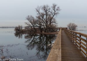
Wheelchair Accessible? Although the road around the 9 mile perimeter of the lake is not officially ADA compliant, it is a hard pack dirt and small gravel road and outside of serious mud and snow times shouldn’t pose a problem. From the Nature Center to a Gazebo reached by a boardwalk over the water is 1.2 miles.  In fair weather this includes a spectacular view of the Front Range, but even on a poor day, the lake, waterfowl and old cottonwoods make a pretty walk.  There is an accessible blind for wildlife observation.
Niedrach NatureTrail is partly boardwalk, and once current improvements are made, may also become wheelchair accessible, although it is a little narrow in places.
Fox Meadows Trail is easy walking, but includes a few steps.

Easy walking boardwalk, Barr Lake State Park
Boardwalk to Waterfowl Observation Point, Barr Lake State Park
view from easy walking trail around Barr Lake, Barr Lake State Park CO
Barr Lake Reservoir, Barr Lake State Park

Cowboy Trail

Wheelchair AccessibleCowboy Recreation and Nature Trail is a 195 mile trail/trail between Valentine and Norfolk. Plans are to continue it west another 126 miles to Chadron.  I’ve been told that the part to Valentine is wheelchair accessible.  However there is some flood damage near Clearwater.  More information about the trail  Kirk Nelson of  Nebraska Game and Parks Commission writes that,  “The best locations for wheelchair use of the trail is in the towns and villages along the way which include Norfolk, Neligh, O’Neil, Bassett, Ainsworth and Valentine. There are accessible toilets in Norfolk, O’Neil and Valentine. Most of the trail outside the urban areas is rough being surfaced with crushed limestone verses concrete in most of the cities and villages.”  He suggests that wheelchair users “…start in the towns and work your way out of town. That way [you] can “test drive” the crushed limestone surface and turn around if [you] have problems.”  He says you will get into nature quickly after leaving the towns.  It is a very rural trail.   Nebraska Game and Parks phone number is  402-471-0641.

Smith Falls State Park

Smith Falls State Park
Smith Falls is on the Niobrara River, a National Scenic River.  The Smith Falls is Nebraska’s highest waterfall.  “Not only is the land home to the beautiful falls, it is also an area of biological significance where several ice age species can still be found.”      Here is the Park website.    Phone 402-376-1306  Map
Both Trip Advisor and Yelp give it good reviews.
Wheelchair AccessibleThe trail to the falls is fine hard packed gravel and is wheelchair accessible.

Wildcat Hills State Recreation Area

Wildcat Hills State Recreation Area
Wildcat Hills SRA has 1,094 acres of wilderness. “The park, which is situated high on a rocky escarpment in the Wildcat Hills, offers an escape to the region’s signature rugged topography and evergreen-studded canyons. Not to mention, the area features an extraordinary view of the North Platte River Valley from its system of trails and observation decks at the nature center. “
Here is the SRA website.  Phone  308-436-3777   Map
HikerwithcaneFrom “Oh Ranger”:  “More than three miles of nature trails wind through the canyons and rocky bluffs, with four main trailheads and foot bridges on three trails. The primary trail is located below the large shelterhouse and is accessible to hikers of all ages and abilities.”

Woodbury County

Woodbury County To learn more about the two areas below, call 701-258-0838
Wheelchair AccessibleDorothy Pecaut Nature Center  at Sioux City has a wheelchair accessible trail. Length not given.   Trail Map
HikerwithcaneFowler Forest has a wooded loop trail which may be easy.  Map

Wheelchair AccessibleLittle Sioux Park (phone 712-372-4984) has a 1 3/4 mile concrete trail.  Map  “The Union Bridge Trail connects the park to the town of Correctionville with a ten foot wide concrete path that winds through scenic areas and crossing the Little Sioux River with a spectacular bridge.”
Wheelchair AccessibleSnyder Bend  (phone 712-946-5622) has an “accessible limestone and concrete trail.”  Map  There is also an accessible fishing dock.