Montana Birding Trail This is an excellent guide to places for birding. Difficulty and accessibility are not addressed, but there is contact information at the bottom of each birding place’s page.
Author: Cecilia
Outdoors for All
Outdoors For All is a Seattle-based nonprofit organization “providing year round instruction in outdoor recreation for people with physical, developmental, and sensory disabilities since 1979. Outdoors for All’s year round programming includes snowboarding, snowshoeing, cross country and downhill skiing, cycling, hiking, river rafting, canoeing and kayaking, day camps, water skiing, rock-climbing, camping and Custom Events.”
Butte-Silver Bow
Butte-Silver Bow
Parks and Recreation
![]() Ulrich/Schotte Nature Trail “is a paved two-mile trail along wetlands, pond and a restored creek. The trail follows Blacktail Creek near Interstate 90, from the Visitors Center on George Street. The …. creek has willowed banks populated with ducks, geese and other birds”
Ulrich/Schotte Nature Trail “is a paved two-mile trail along wetlands, pond and a restored creek. The trail follows Blacktail Creek near Interstate 90, from the Visitors Center on George Street. The …. creek has willowed banks populated with ducks, geese and other birds”
![]() According to the Montana Disability and Health Program website, there are 22 miles of “paved, handicapped accessible trails [that] wrap through and around the city of Butte.” It doesn’t say to what degree any of these go into natural areas.
According to the Montana Disability and Health Program website, there are 22 miles of “paved, handicapped accessible trails [that] wrap through and around the city of Butte.” It doesn’t say to what degree any of these go into natural areas.
Billings
Billings
![]() Two Moon Park “Two Moon Park (Yellowstone County) contains several narrow, gravel-surfaced trails that wind through stands of cottonwoods above and beside the storied Yellowstone River. The trails – Roche Jeune, Dull Knife, Mallard and Weeping Wall – can be linked together in various ways to come up with a number of do-it-yourself of loops and out-and-backs.” ….”At the Two Moon Park entrance you can jump onto the paved Dutcher Trail ,…. which from there winds down to the Yellowstone then upstream to Coulson Park.”
Two Moon Park “Two Moon Park (Yellowstone County) contains several narrow, gravel-surfaced trails that wind through stands of cottonwoods above and beside the storied Yellowstone River. The trails – Roche Jeune, Dull Knife, Mallard and Weeping Wall – can be linked together in various ways to come up with a number of do-it-yourself of loops and out-and-backs.” ….”At the Two Moon Park entrance you can jump onto the paved Dutcher Trail ,…. which from there winds down to the Yellowstone then upstream to Coulson Park.”
![]() Swords Park Trail is 3.8 miles and described by the Rails-to-Trails Conservancy as wheelchair accessible.
Swords Park Trail is 3.8 miles and described by the Rails-to-Trails Conservancy as wheelchair accessible.
![]() Norm Schoenthal Island Trail 1.9 miles. Reviewers on AllTrails.com describe it as easy, and full of off-leash dogs and mosquitos. Best to go early in the morning.
Norm Schoenthal Island Trail 1.9 miles. Reviewers on AllTrails.com describe it as easy, and full of off-leash dogs and mosquitos. Best to go early in the morning.
Here is a website from Billings Parks and Recreation. It describes local trails by categories such as soft or hard surface. I suspect many of these trails would qualify for this website, but ease and accessibility are not directly addressed. Their telephone number is (406) 657-8371.
Helena – Lewis and Clark National Forest
Helena – Lewis and Clark National Forest
These two Forests, now joined into one, amount to about 2,846,600 acres in central Montana in the Rocky Mountains, straddling the Continental Divide and including multiple mountain ranges. There are 8 ranger districts.
Here is the Forest website. Description from National Forests Foundation.
Phone numbers: Helena Supervisor’s Office: 406-449-5201, Great Falls Supervisor’s Office: 406-791-7700, Lewis and Clark Interpretive Center: (406) 727-8733.
![]() Trout Creek Canyon Trail The first mile of this three mile trail through Trout Creek Canyon is wheelchair accessible. The remaining two miles are described as easy with an elevation gain of 800′. “Hikers can pick up an interpretive brochure at the trailhead signboard that hikers can refer to as they reach one of the ten numbered benchmarks along the first mile of their hike.”
Trout Creek Canyon Trail The first mile of this three mile trail through Trout Creek Canyon is wheelchair accessible. The remaining two miles are described as easy with an elevation gain of 800′. “Hikers can pick up an interpretive brochure at the trailhead signboard that hikers can refer to as they reach one of the ten numbered benchmarks along the first mile of their hike.”
![]() Tenmile Environmental Trail Interpretive Guide 1.1 mile loop
Tenmile Environmental Trail Interpretive Guide 1.1 mile loop
Spring Meadow Lake State Park
Spring Meadow Lake State Park
Spring Meadow Lake State Park, on the western edge of Helena, is “an urban day-use park and is a popular spot for family afternoons of swimming, sunbathing, fishing, birdwatching, and having fun. ”
Here is the Park website. Phone:406-449-5109 (summer) or the office: 406-495-3270. Trail Map
![]() The Spring Meadow Lake State Park trail goes around the lake and has a fishing pier. TrailLink describes it as 2 miles, but the Park map and website say 0.8 mile!
The Spring Meadow Lake State Park trail goes around the lake and has a fishing pier. TrailLink describes it as 2 miles, but the Park map and website say 0.8 mile!
Flathead National Forest
Flathead National Forest
Flathead National Forest’s 2.4 million acres include three wilderness areas. The Forest offers numerous lakes, streams, and rivers and is home to an abundance of wildlife including lynx, grizzly bear, and bull trout. There are five ranger districts. Description from National Forests Foundation. Here is the Forest website.
Phones – Tally Lake Ranger District: 406-758-5204; Glacier View, Spotted Bear (winter) and Hungry Horse Ranger Districts: 406-387-3800. Spotted Bear (summer) 406-758-5376; Swan Lake Ranger District 406-837-7500.
![]() Krause Basin Interpretive Trail is a 0.25 mile loop with ” 12 numbered stations with interpretive information provided via a trail guide brochure available at the trail head. The trail loops through a stand of old-growth western hemlock forest and a regenerating clearcut logged in the 1960s. The trail guide provides information on how forests recycle themselves and provide benefits to humans from medicine to lumber. The trail has a compacted gravel surface suitable for baby strollers and wheelchairs.”
Krause Basin Interpretive Trail is a 0.25 mile loop with ” 12 numbered stations with interpretive information provided via a trail guide brochure available at the trail head. The trail loops through a stand of old-growth western hemlock forest and a regenerating clearcut logged in the 1960s. The trail guide provides information on how forests recycle themselves and provide benefits to humans from medicine to lumber. The trail has a compacted gravel surface suitable for baby strollers and wheelchairs.”
Yellowstone National Park
Yellowstone National Park
Yellowstone National Park overlies the huge Yellowstone Caldera. The Park’s diversity and natural wealth include hydrothermal features such as colorful hot springs, mudpots, and geysers. There is abundant wildlife, vegetation, lakes, and the Yellowstone River with its canyon and falls. “In Yellowstone, the interplay between volcanic, hydrothermal, and glacial processes, and the distribution of flora and fauna are intricate.”
The park is in both Wyoming and Montana, so I am posting in both states.
Here is the Park website. Phone 307-344-7381 Accessibility Guide
The Accessibility Guide is very thorough so I am posting just a bit about some of the accessible places in Yellowstone.
“Manual wheelchairs can be rented at medical clinics for $10 per day with a credit card (or $300 cash) deposit. Wheelchairs are available for loan at each lodging facility, except Roosevelt Lodge, and the Old Faithful, Canyon, and Albright (Mammoth) visitors centers while in those areas.”
The use of Segways is somewhat limited. Check ahead.
![]() Mammoth Hot Springs. There are accessible boardwalk from which you can view the Mammoth Hot Springs Terraces.
Mammoth Hot Springs. There are accessible boardwalk from which you can view the Mammoth Hot Springs Terraces.
![]() Norris Geyser Basin and Area. There are boardwalks here, but you may need assistance. The lower section of the Artists Paintpots is wheelchair accessible.
Norris Geyser Basin and Area. There are boardwalks here, but you may need assistance. The lower section of the Artists Paintpots is wheelchair accessible.
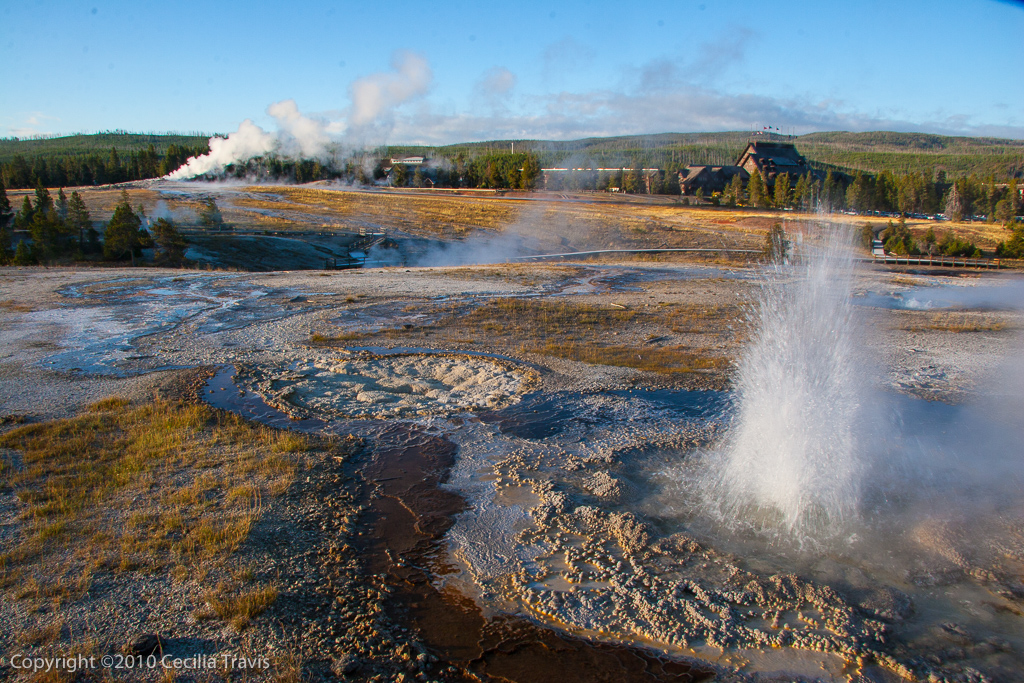
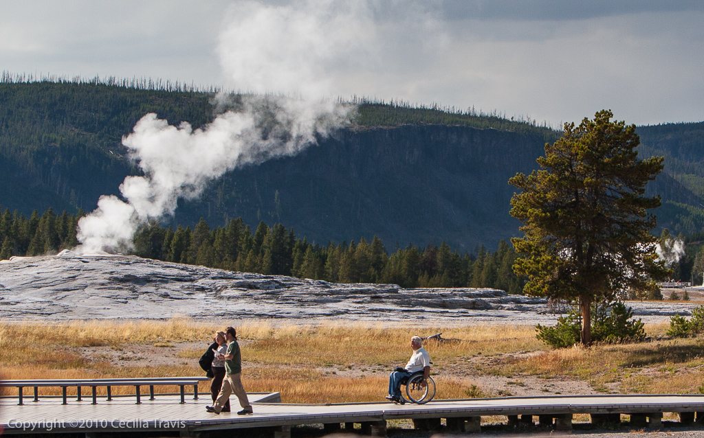
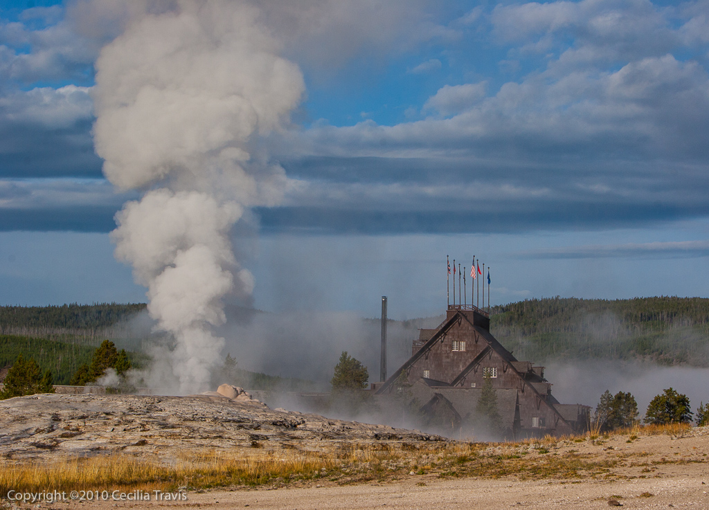
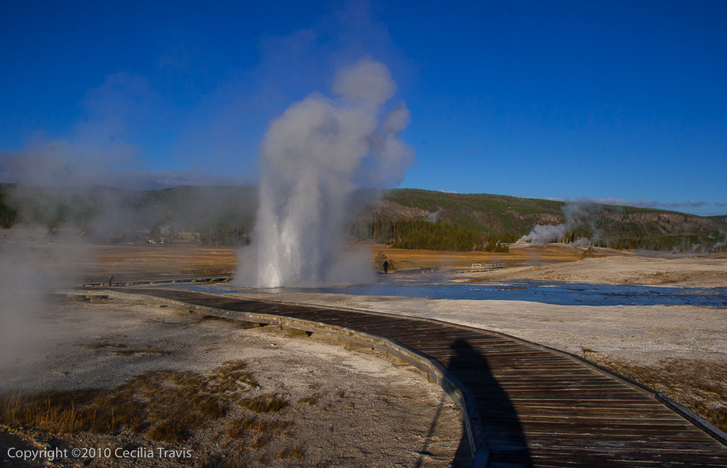
![]() Old Faithful. There are accessible paved trails and boardwalks going to Old Faithful Geyser, Geyser Hill, and Castle Geyser
Old Faithful. There are accessible paved trails and boardwalks going to Old Faithful Geyser, Geyser Hill, and Castle Geyser
![]() West Thumb Geyser Area. You may require some assistance on these boardwalks, which are by Yellowstone Lake.
West Thumb Geyser Area. You may require some assistance on these boardwalks, which are by Yellowstone Lake.
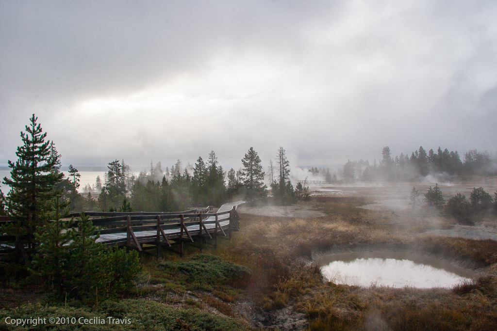
![]() Fishing Bridge Area. There is an accessible trail to the Mud Volcano, 6 miles north of Fishing Bridge.
Fishing Bridge Area. There is an accessible trail to the Mud Volcano, 6 miles north of Fishing Bridge.
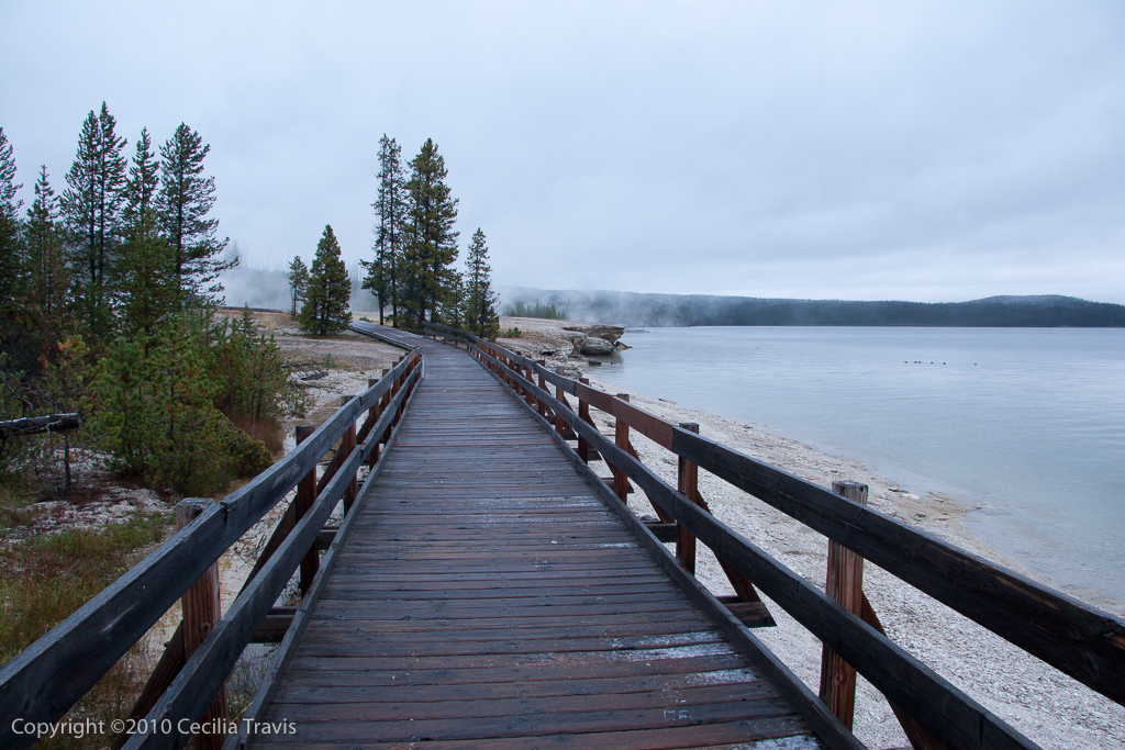
![]() Grand Canyon of the Yellowstone River. There are a number of accessible trails to overlooks. See the map in the Accessibility Guide.
Grand Canyon of the Yellowstone River. There are a number of accessible trails to overlooks. See the map in the Accessibility Guide.
Salem, MO
Salem
![]() Salem Frisco RR Trail “Starting at 3rd and Grand Avenue in Salem, the trail is an 8 foot wide asphalt path traveling north for 4,000 feet along the Old Burlington Northern Railroad bed. It ends at the old timber trestle over Spring Creek near the MFA Bulk Plant just off Hwy 19 on the north edge of Salem.” As described by Libby of the Bonebrake Conservation Nature Center: it is “a converted railroad bed about 3/4 mi. long. It starts at the edge of town and goes past some pasture and woods (and also the sewer treatment plant, but not stinky!). Very flat, essentially chip and seal finish. Very good for wheelchairs and walkers.”
Salem Frisco RR Trail “Starting at 3rd and Grand Avenue in Salem, the trail is an 8 foot wide asphalt path traveling north for 4,000 feet along the Old Burlington Northern Railroad bed. It ends at the old timber trestle over Spring Creek near the MFA Bulk Plant just off Hwy 19 on the north edge of Salem.” As described by Libby of the Bonebrake Conservation Nature Center: it is “a converted railroad bed about 3/4 mi. long. It starts at the edge of town and goes past some pasture and woods (and also the sewer treatment plant, but not stinky!). Very flat, essentially chip and seal finish. Very good for wheelchairs and walkers.”
Dent County MO
Dent County
![]() Tiger Trail is “behind the Upper Elementary School on Doss Road. It has a nice surface, wide trails that meander through the brush, trees, and [have] a few steep inclines but generally mild rises and dips, nice chat/gravel for walking and wheelchairs that are sturdy. Lots of cut offs and loops and can be very short or up to nearly 2 miles if you take the long way.” Contributed by Libby of the Bonebrake Center of Nature and History.
Tiger Trail is “behind the Upper Elementary School on Doss Road. It has a nice surface, wide trails that meander through the brush, trees, and [have] a few steep inclines but generally mild rises and dips, nice chat/gravel for walking and wheelchairs that are sturdy. Lots of cut offs and loops and can be very short or up to nearly 2 miles if you take the long way.” Contributed by Libby of the Bonebrake Center of Nature and History.